Maine and Alaska both use instant-runoff voting for House elections.
21 Matching Annotations
- May 2026
-
-
- Mar 2025
-
www.youtube.com www.youtube.com
-
for - Canada could troll Us policy - annex Alaska
-
- Jul 2024
-
www.saschafast.de www.saschafast.de
-
The trees with deep roots are the ones that grow tall. — Frédéric Mistral
original source?
This quote works well for individuals, but looking at tree stands in Alaska only thousands of years from glaciation, one sees incredibly tall trees that have shallow root systems, but they utilize each others' root systems to keep groups of trees strong and tall. This apparently even extends to groups of trees looking out for each other to keep the group strong.
-
- May 2024
-
www.theguardian.com www.theguardian.com
-
Mit Alaska LNG genehmigt die US-Regierung kurz nach dem Willow-Projekt ein weiteres fossiles Megaprojekt. Zu diesem Vorhaben, dass 2030 umgesetzt sein soll, gehören eine Erdgasverflüssigungsanlage und eine Pipeline. Es geht um eine Summe von 39 Milliarden Dollar. Weitere Genehmigungen von Investitionen für LNG Infrastruktur sind beabsichtigt. https://www.theguardian.com/us-news/2023/apr/14/biden-alaska-lng-liquefied-natural-gas-exports
-
- Sep 2023
-
www.nytimes.com www.nytimes.com
-
Die Biden-Administration hat das Bohren nach Öl und Gas in einem großen Teil eines Schutzgebiets in Alaska untersagt und bereits vorhandene Bohrlizenzen beendet. Damit nahm sie eine demonstrative Entscheidung der Trump-Regierung zurück. Biden reagierte damit auch auch auf die Empörung über die Erlaubnis für das Willow-Project, das als Zündung einer Carbon Bomb in der Arktis gilt.
https://www.nytimes.com/2023/09/06/climate/biden-drilling-alaska-wildlife-refuge.html
-
- Aug 2023
-
www.repubblica.it www.repubblica.it
- Aug 2022
-
www.nytimes.com www.nytimes.com
-
Reportage über einen besonders verheerenden Waldbrand in Alaska, viele Hintergrundinformationen über Waldbrände in arktischen Regionen. Zeigt den multiplen Charakter der durch die Erhitzung ausgelösten Krise eines Ökosystems.
-
- Apr 2022
-
twitter.com twitter.com
-
ReconfigBehSci on Twitter: ‘RT @TheLancetInfDis: Newsdesk in March issue: #COVID19 among American Indians and Alaska Natives https://t.co/cJj2815IYw’ / Twitter. (n.d.). Retrieved 3 March 2021, from https://twitter.com/SciBeh/status/1367060643896053760
-
- Oct 2021
-
www.theguardian.com www.theguardian.com
-
Schreiber, M. (2021, September 24). ‘It’s awful. It’s exhausting’: Alaska rations care as it hits Covid nadir. The Guardian. https://www.theguardian.com/us-news/2021/sep/24/alaska-covid-coronavirus-rations-care-hospitals
-
- Mar 2021
-
www.thelancet.com www.thelancet.com
-
Burki, T. (2021). COVID-19 among American Indians and Alaska Natives. The Lancet Infectious Diseases, 21(3), 325–326. https://doi.org/10.1016/S1473-3099(21)00083-9
-
- Sep 2017
-
www.youthvoices.live www.youthvoices.liveAbout Me1
-
The rest of the hobbies were either self taught or taught by my past teachers. In terms of gaming, I have taken part of many different Alpha, Beta, and Common Tests for various games from World of Warcraft to War Thunder.
May I say that being able to test the different levels of game during it's production is pretty cool. I do enjoy being able to test games via GameJolt. To see the potential people have. Recently I've played and checked a game called Alaska (I think). A game being made by only one man and so far it is only I'm quite sure Alpha. It's doing quite well so far and looks like it has quite a bit of potential.
-
- Jul 2017
-
www.musikexpress.de www.musikexpress.de
-
Portugal. The Man: Woodstock [oooo]
VÖ: 16.6.2017
-
- May 2017
-
nfnh2017.scholar.bucknell.edu nfnh2017.scholar.bucknell.edu
-
Alyeska oil pipeline
The oil discovered in the Prudhoe Bay oil field in the North Slope region of Alaska in 1968 was the “largest oil field discovered in North America.” In 1969, a Trans-Alaska pipeline to transport oil from the North Slope was proposed by the Trans-Alaska Pipeline System. The Trans-Alaska Pipeline System was comprised of three major oil corporations. Despite many other ideas and suggestions to transport this oil, the oil industry reached a consensus in favor of the pipeline proposal of the Trans-Alaska Pipeline System (Busenberg, 2013). Construction of the Alyeska oil pipeline, also known as the Alaska pipeline or trans-Alaska pipeline, began in 1975. This pipeline was built by the Alyeska Pipeline Service Company, a group that was made up of seven different oil companies. In certain regions, the pipeline is buried underground, but where there is permafrost, the pipeline is constructed above the ground. The pipeline crosses over 800 river and streams and passes through three mountain ranges. The first oil was delivered from Prudhoe Bay to Valdez on June 20, 1977. This oil had to travel through the 789 mile long pipeline to reach its destination (Alaska Public Lands Information Centers, n.d.). See below for a link to “Pipeline! The story of the building of the trans-Alaska pipeline” video posted on YouTube by the Alaska National Parks service.https://www.youtube.com/watch?v=WmO6loYsm4Q


References
Alaska Public Lands Information Centers. (n.d.). The Trans-Alaska Pipeline. Retrieved from Alaska Public Lands Information Centers: https://www.alaskacenters.gov/the-alyeska-pipeline.cfm
Busenberg, G. J. (2013). The Trans-Alaska Pipeline System. In G. J. Busenburg, Oil and Wilderness in Alaska (pp. 11-43). Georgetown University Press.
-
trans-Alaska pipeline
The Trans-Alaska Pipeline Project began construction on March 27, 1975. The pipeline was constructed in response to the discovery of oil under the Purdhoe Bay (Alaska Public Lands Information Centers). The project was controversial because environmentalists worried about earthquakes and the effects on elk migrations (Wells). The pipeline is almost 800 miles long and includes pumping stations that connected other pipelines. The pipeline was constructed by the Alyeska Pipeline Service Company, which was created by seven oil companies (Wells, Alaska Public Lands Information Centers). The pipeline is mostly below ground, except in areas of permafrost. The sections of pipe that were built above ground were built in a zigzag pattern to account for expansion due to temperature changes (Wells). In unseasonably warm areas, the pipeline is supported by two thicker “heat pipes.” The pipeline was completed on May 31, 1977 (Alaska Public Lands Information Centers). The pipeline first contained oil on June 20, 1977. The pipeline carries about 1.8 million barrels of oil per day. In March of 1989, an oil tanker leaked over 260,000 barrels of oil into the Prince William Sound. This was the second largest oil spill in the United States. The spill covered 1300 miles of land and 11,000 miles of ocean. Images of the pipeline can be seen below. http://aoghs.org/transportation/trans-alaska-pipeline/
References:
"Trans-Alaska Pipeline History." American Oil & Gas Historical Society. June 21, 2016. Accessed May 05, 2017. http://aoghs.org/transportation/trans-alaska-pipeline/.
"The Trans-Alaska Pipeline." The Trans-Alaska Pipeline. Accessed May 05, 2017. https://www.alaskacenters.gov/the-alyeska-pipeline.cfm.
-
-
enst31501sp2017.courses.bucknell.edu enst31501sp2017.courses.bucknell.edu
-
Trans-Alaska pipeline,

This map shows the 800-mile Trans-Alaska Pipeline System (TAPS), also called the Alyeska Pipeline, that was built in the 1970s with 11 pumping stations that transports crude oil from Prudhoe Bay to Port Valdez. The pipeline cost around $8 billion to build. The link below provides facts on the pipeline provided by the Alyeska Pipeline Service Company: http://www.alyeska-pipe.com/TAPS/PipelineFacts
About the Trans-Alaska Pipeline System. Accessed April 30, 2017. http://www.treasure-hunt.alaska.edu/ch5/info_pipeline.html.
-
1002 area
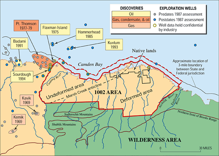
This map shows a more detailed version of the 1002 area, located in the north section of the Arctic National Wildlife Refuge. This map also shows the location of the Native property that is at risk of being drilled.
USGS. "Arctic National Wildlife Refuge, 1002 Area, Petroleum Assessment, 1998, Including Economic Analysis." USGS: Science for a Changing World. Accessed April 28, 2017.
-
- Apr 2017
-
nfnh2017.scholar.bucknell.edu nfnh2017.scholar.bucknell.edu
-
Carson Templeton
Carson H. Templeton was born in Wainwright, Alberta. He earned a diploma studying Mining Engineering at the Southern Alberta Institute of Technology (SAIT) in Calgary, Alberta. He worked at the Madsen Red Lake Mine in Northwest Ontario as an Assistant Assayer, Boat Boy, and Post Office Manager. He attended the University of Alberta to continue his studies of Mining Engineering and graduated with a Bachelor of Science. During World War II, Templeton worked on the Canol Pipeline Project. He then helped construct airports alongside the Alaska Highway for military use. In 1948, Templeton was appointed Assistant Chief Engineer of the Fraser Valley Dyking Board. In 1950, Templeton was appointed Chief Engineer of the Greater Winnipeg Dyking Board. In 1955, Templeton founded a consulting engineering firm which he named the Templeton Engineering Company. Before the Unicity Amalgamation of Winnipeg in 1972, his company worked as the City Engineer for several small cities in Canada. His company performed engineering estimates for the Royal Commission on Flood Cost-Benefits. These calculations led to the construction of the Winnipeg Floodway. Additionally, Carson Templeton’s consulting engineering firm conducted research that supported the writing of “Snow and Ice Roads: Ability to Support Traffic and Effects on Vegetation” by Kenneth Adam and Helios Hernandez (Adam and Hernandez 1977). In 1966, his company merged with Montreal Engineering and Shawinigan Engineering to form Teshmont Consultants Ltd. Teshmont Consultants Ltd. has completed over 50 percent of the world’s high-voltage, direct current projects. Templeton served as the Chairman of the Alaska Highway Pipeline Panel and Chairman of the Environmental Protection Board during the 1970s. As the Chairman of the Environmental Protection Board, Templeton orchestrated the hearing process for the Environmental Impact Assessments for the Mackenzie Valley Pipeline Inquiry (Winnipeg Free Press 2004).References
Adam, Kenneth, and Helios Hernandez. "Snow and Ice Roads: Ability to Support Traffic and Effects on Vegetation." Arctic, 1977: 13-27.
Winnipeg Free Press. Carson Templeton OC. October 10, 2004. http://passages.winnipegfreepress.com/passage-details/id-89334/Carson_Templeton_#/ (accessed April 8, 2017).
-
Alaska Highway
The Alaska Highway was originally constructed for and used by the military during World War II which lasted from 1939 to 1945. It was opened in November of 1942. Its length reached nearly 1,525 miles. When Richard Bucksar wrote his article The Alaska Highway Development published in the journal Arctic Volume 27, Number 1 in 1974, the Alaska Highway had not been paved in its entirety despite many proposals to do so. In 1974, it remained mostly a gravel road described as “rough and uneven” (Bucksar 1974, 74). About 400 of the 1,525 miles were paved.

Since the Alaska Highway passes through Canadian territory to connect the continental United States to Alaska, both country’s governments had to be consulted regarding improvements to the Alaska Highway. The Canadian Parliament and United States Congress were presented with numerous proposals to improve the Alaska Highway including improving the road, developing railways, introducing new sea-routes, reconstructing, paving, etc. (Bucksar 1974, 74-75). Mostly all of these propositions were not passed since alternate “adequate modes of transportation were developing and that the expected traffic on the [Alaska] Highway did not warrant reconstruction and paving at that time” (Bucksar 1974, 78).

The Alaska Highway was the only land-based link between Alaska and the continental United States. Some towns, cities, and other landmarks that the Alaska Highway passes through include Dawson Creek, Fort Saint John, Fort Nelson, Muncho Lake Provincial Park, Liard River Hotsprings Provincial Park, Watson Lake, Teslin, Whitehorse, Halnes Junction, Beaver Creek, Delta Junction, North Pole, Fairbanks, and many more. A detailed current map of the Alaska Highway is displayed below.


References
The Milepost. Alaska Highway. 2016. https://www.themilepost.com/highway-info/highways/alaska-highway (accessed April 4, 2017).
Bucksar, Richard G. "The Alaska Highway Development." Arctic 27, no. 1 (1974): 74-80. http://www.jstor.org.ezproxy.bucknell.edu/stable/40508483.
-
-
enst31501sp2017.courses.bucknell.edu enst31501sp2017.courses.bucknell.edu
-
Kaktovik, Alaska
This is a documentary by National Geographic that analyzes the impacts of oil companies and oil development in Alaska that is slowly moving towards oil extraction in the Arctic National Wildlife Refuge. It includes a basic overview of oil development in the Arctic as well as interviews from the Public Relations Chair of Chevron, as well as a Kaktovik resident, whose town controls 92,000 acres of oil-rich land in the Refuge. The Kaktovik people are at a crossroads because they could partake in the profit of the oil drilling, but it means that their land is destroyed. This allows a comparison of perspectives from the oil companies and the native people who are affected by drilling.
Alaska's Last Oil. Directed by National Geographic. December 8, 2010. Accessed March 26, 2017.
-
- Mar 2017
-
nfnh2017.scholar.bucknell.edu nfnh2017.scholar.bucknell.edu
-
the Beaufort Sea
The Beaufort Sea is a division of the Atlantic Ocean in northwest Canada and northwest Alaska. It is where the Mackenzie River empties into the Canadian side of the sea. This area of the Arctic is known to be a major source of oil and petroleum. It has been the target of pipeline and drilling projects both in the past and presently.
Not much has changed for the Beaufort Sea when it comes to oil extraction. Recently, new oil and gas drilling has been suspended for the next five years in the Beaufort Sea in order for the US and Canada to evaluate the environmental impacts drilling would have on the area. In the 1970’s when this article was written, the same caution was taken by both governments in order to understand the impacts that the pipeline would have on the area and it’s inhabitants. Currently, although the Beaufort Sea is a major reserve for gas and petroleum, it is still dangerous to drill. The landscape of the arctic is much different of that in the Gulf of Mexico, making it more difficult and more dangerous to drill. Even after three decades, this area is still facing the same challenges with its reserves.
Annotation taken from Amman, Jordan Canada cancel extension of the existing Arctic offshore oil exploration licenses. (Energy Monitor Worldwide, 2017)
-