https://www.si.edu/object/archives/sova-nmah-ac-0260<br /> Railway Express Agency Records<br /> American History Museum
74 Matching Annotations
- Jun 2026
-
housing.colostate.edu housing.colostate.edu
-
All transportation devices on campus must be registered for a small fee of $10The Spoke, located in Laurel Village offers low-cost bike repair services
-
-
hr.colostate.edu hr.colostate.edu
-
Download and sign up for the Way to Go app to find people who live and work near you and may be interested in carpooling.
-
- Apr 2025
-
www.derstandard.at www.derstandard.at
-
Im neuesten Entwurf des Aktionsplans für die europäische Automobilindustrie wird das sogenannte Verbrennerverbot nicht mehr erwähnt. Auch bei den Flottengrenzwerten für den Treibhausgasausstoß werden die Bestimmungen weiter gelockert. Die EVP Renew Europe und die deutsche Automobilindustrie sind Ha uptaktdierere hinter dieser Auffachung der europäischen Klimapolitik. https://www.derstandard.at/story/3000000263785/neuer-kommissionsentwurf-wird-das-verbrenner-aus-bald-endgueltig-gekippt
-
- Mar 2025
-
blogs.lse.ac.uk blogs.lse.ac.uk
-
if everyone emitted carbon at the same rate as the luxury transport emissions of 50 of the world’s richest billionaires, the remaining carbon budget would be gone in two days
for - carbon inequality - stats - carbon inequality - 2 days of our carbon budget - if everyone emitted transportation emissions of 50 richest billionaires - source - Oxfam - Carbon Inequality kills - 2024
Tags
Annotators
URL
-
-
www.nytimes.com www.nytimes.com
-
He Gave a Name to What Many Christians Feel by [[Ruth Graham]], [[Madeleine Hordinski]]
-
- Jan 2025
-
-
A shared car association, every shared car replaces 9 to 13 private cars for the same amount of travel freedom, point to point. You don't lose any freedom like you would in public transport. It's just like a neighborhood shares a dozen cars. 95% of the cars are in the garage at any time.
for - example - efficacy of mutualisation - transportation - cars - SOURCE - Youtube Ma Earth channel interview - Devcon 2024 - Cosmo Local Commoning with Web 3 - Michel Bauwens - 2025, Jan 2 - stats - mutualisation - transportation - cars - 1 car can replace 13 - car is parked most of the time - 10% of existing cars doubles our requirement - SOURCE - Youtube Ma Earth channel interview - Devcon 2024 - Cosmo Local Commoning with Web 3 - Michel Bauwens - 2025, Jan 2
Tags
- example - efficacy of mutualisation - transportation - cars - SOURCE - Youtube Ma Earth channel interview - Devcon 2024 - Cosmo Local Commoning with Web 3 - Michel Bauwens - 2025, Jan 2
- stats - mutualisation - transportation - cars - 1 car can replace 13 - car is parked most of the time - 10% of existing cars doubles our requirement - SOURCE - Youtube Ma Earth channel interview - Devcon 2024 - Cosmo Local Commoning with Web 3 - Michel Bauwens - 2025, Jan 2
Annotators
URL
-
- Sep 2024
-
www.theguardian.com www.theguardian.com
-
Der Flugtourismus hat.inzwischen das Niveau vor der Covid-Krise übertroffen. Das Wachstum des Tourismus gehört zu den wichtigsten Treibern der Klimakrise. Die Branche reagiert darauf mit Ignoranz, Greenwashing und dem Verweis auf falsche Lösungen wie CO<sub>2</sub>-Kompensatio und Biofuels. Hintergrundartikel mit Verweisen auf weitere Informationen.https://www.theguardian.com/news/article/2024/sep/06/flight-shame-climate-impact-tourism-boom-covid-environment-net-zero
Tags
- Travalyst
- carbon offsets
- International Council on Clean Transportation (ICCT)
- Transport and Environment
- Thomas Earl
- Stefan Gössling
- Hannah Lawrence
- Andrea Papu Carrone
- Stay Grounded
- Tourismus
- by: Ajit Niranjan
- Anna Spenceley
- Luis Martinez
- International Transport Forum (ITF)
- Flugindustrie
- false solutions
Annotators
URL
-
- Aug 2024
-
www.ihpva.org www.ihpva.org
-
for - sustainable transportation - velocar sources - IHPVA - international human powered vehicle association - branches
-
-
www.theguardian.com www.theguardian.com
-
2024 werden 6% mehr Menschen auf Kreuzfahrtschiffen unterwegs sein als vor der Pandemie. Neue Studie von Transport & Environment zum Wachstum dieses besonders energieintensiven Teils der Tourismusindustrie. https://www.theguardian.com/environment/article/2024/aug/07/cruisezilla-passenger-ships-have-doubled-in-size-since-2000-campaigners-warn
-
- May 2024
-
-
for - alternative transportation - velocar - velocar - Tilt4orce
-
- Feb 2024
-
-
for - sustainable transportation - solar powered car - Aptera
-
- Jan 2024
-
-
Eine Studie zeigt, dass die CO2-Emissionen deutscher Neuwagen 14,1% höher sind, als es die Hersteller angeben. 2018 lag der Unterschied durchschnittlich bei 7,7%. https://taz.de/CO2-Werte-neuer-Fahrzeuge/!5985888/
-
-
www.repubblica.it www.repubblica.it
-
2022 haben Kreuzfahrtschiffe in Europa mehr Stickoxide ausgestoßen als der gesamte Autoverkehr Punkt der CO2 Fußabdruck einer Kreuzfahrt ist höher als bei einer vergleichbar weiten Flugreise mit hotelaufenthalt Punkt die Republica informiert über die katastrophalen Emissionen von Kreuzfahrtschiffen. https://www.repubblica.it/green-and-blue/2024/01/29/news/navi_crociera_inquinamento_ambiente-422001318/
-
- Sep 2023
-
www.repubblica.it www.repubblica.it
-
Die EU hat seit 1995 1500 Milliarden Euro in der Straßennetz investiert 66% mehr als in das Eisenbahnnetz. Während das Autobahnnetz um 60% ausgebaut wurde, wurde das Eisenbahnnetz um 6,5% reduziert. Die Treibhausgasemissionen des Verkehrs wuchsen zwischen 1995 und 2019 um 15%. Die Zahlen stammen aus einer umfassenden Studie zur Entwicklung der europäischen Verkehrsinfrastruktur vielleicht aber doch Infrastruktur oder, die von Greenpeace in Auftrag gegeben wurde
Tags
- 2023-09-19
- institution: Wuppertal Institut
- institution: T3 Transportation Think Tank
- country: EU
- expert: Federico Spadini
- study: Development of Transport Infrastructure in Europe
- NGO: Greenpeace
Annotators
URL
repubblica.it/green-and-blue/2023/09/19/news/greenpeace_trasporti_europa_autostrade_treni-415017423/ -
-
www.york.ac.uk www.york.ac.uk
-
- for: velocar, low carbon transportation
- title: Up the velorution: appropriating the bicycle and the politics of technology
-
-
citeseerx.ist.psu.edu citeseerx.ist.psu.edu
-
- for: velocar, low carbon transportation
- Title: The Velomobile as a Vehicle for more Sustainable Transportation
-
- Aug 2023
-
www.sustainable.org.za www.sustainable.org.za
-
- for: sustainable transport, Cape Town, Cape Town - sustainable transport, Heinrich Boiller
- Description
- Heinrich Boiller study on sustainable transportation for the city of Cape Town
-
-
www.tandfonline.com www.tandfonline.com
-
Views 0 CrossRef citations to date 32 Altmetric Research Article The spatial and social logic of the Minibus Taxi network: how access may support social inclusion in Cape Town, South Africa
- for: cape town transportation, minibus industry South Africa , Cape Town, sustainable transportation, informal transport
- title
- Views 0 CrossRef citations to date 32 Altmetric Research Article The spatial and social logic of the Minibus Taxi network: how access may support social inclusion in Cape Town, South Africa
- date
- May 24, 2021
- author
- Ruth Joan Nelson
- source
- Applied Mobilities
- https://www.tandfonline.com/doi/abs/10.1080/23800127.2021.1926054
-
- Feb 2023
-
www.cnbc.com www.cnbc.com
-
How the TSA's Instagram became a must-follow account, thanks to a sticky-note trick by Natasha Piñon
read on Fri 2022-12-09 7:28 AM
-
- Dec 2022
-
www.e-flux.com www.e-flux.com
-
If I were asked to condense the whole of the present century into one mental picture I would pick a familiar everyday sight: a man in a motor car, driving along a concrete highway to some unknown destination … I think that the 20th century reaches almost its purest expression on the highway. Here we see, all too clearly, the speed and violence of our age, its strange love affair with the machine and, conceivably, with its own death and destruction.
Cars weirdly coffin-shaped; thinking about the death of distance, the impatience between points, and the necessity to kill intervening 'dead' time spent in transit
-
- Sep 2022
-
bam.kalzumeus.com bam.kalzumeus.com
-
Bank branches are not destinations. Like Starbucks and cell phone shops, they rely on capturing your day-to-day custom when you’re out and about. In the U.S., that mostly means being maximally accessible by cars. (In Japan, and other places with different transit behavior, bank branches are among the most likely user for large parcels directly adjacent to hub train stations, with smaller light branches and ATM-only locations being deployed close to far-from-station workplaces.)
Bank branches are not destinations
Banks situate themselves along the paths that people travel...they are not destinations in and of themselves. So placement of branches are guided by modes of transportation: easy car access when cars at the main mode of transport; near transit stops when public transportation is the main mode.
-
- Jan 2022
-
theconversation.com theconversation.com
-
Stanford, J. (n.d.). Healthy humans drive the economy: We’re now witnessing one of the worst public policy failures in Australia’s history. The Conversation. Retrieved January 12, 2022, from http://theconversation.com/healthy-humans-drive-the-economy-were-now-witnessing-one-of-the-worst-public-policy-failures-in-australias-history-174606
Tags
- government
- essential services
- labour
- agriculture
- lang:en
- transportation
- emergency services
- child care
- logistics
- lockdown
- restrictions
- COVID-19
- workforce
- data
- policy
- supply chain
- health care
- Australia
- manufacturing
- Omicron
- production
- isolation
- is:webpage
- staff shortage
- technology
- economy
Annotators
URL
-
- Nov 2021
-
www.bloomberg.com www.bloomberg.com
-
Gates Foundation Offers $4 Million to Fix Syringe Shortage for Covid Shots. (2021, November 4). Bloomberg.Com. https://www.bloomberg.com/news/articles/2021-11-04/gates-takes-on-next-barrier-to-rolling-out-covid-shots-syringes
-
- Oct 2021
-
www.excellentwebworld.com www.excellentwebworld.com
-
The best part is you can start your transportation business with one single van and later expand as you grow. We’ll talk more on this later in the blog.
-
-
www.reuters.com www.reuters.com
-
Scherer, S., & Gordon, J. (2021, October 6). Canada imposes COVID-19 vaccine mandate on federal workers, transportation. Reuters. https://www.reuters.com/world/americas/unvaccinated-federal-workers-canada-will-be-put-unpaid-leave-globe-mail-2021-10-06/
-
- Jul 2021
-
www.gutenberg.org www.gutenberg.org
-
We left Charing Cross on the morning of the 12th, got to Paris the same night, and took the places secured for us in the Orient Express.
-
English Bradshaw’s Guide
-
Great Northern Railway. Same are to be delivered at Carfax, near Purfleet, immediately on receipt at goods station King’s Cross
-
- Jun 2021
-
www.gutenberg.org www.gutenberg.org
-
He stopped to talk with me, as he always does, but all the time kept looking at a strange ship. “I can’t make her out,” he said; “she’s a Russian, by the look of her; but she’s knocking about in the queerest way. She doesn’t know her mind a bit; she seems to see the storm coming, but can’t decide whether to run up north in the open, or to put in here. Look there again! She is steered mighty strangely, for she doesn’t mind the hand on the wheel; changes about with every puff of wind. We’ll hear more of her before this time to-morrow.”
Demeter. The ship carrying Dracula.
-
train
-
on the coach the driver
-
- Apr 2021
-
journals.plos.org journals.plos.org
-
Sy, Karla Therese L., Laura F. White, and Brooke E. Nichols. ‘Population Density and Basic Reproductive Number of COVID-19 across United States Counties’. PLOS ONE 16, no. 4 (21 April 2021): e0249271. https://doi.org/10.1371/journal.pone.0249271.
-
- Mar 2021
-
www.telegraph.co.uk www.telegraph.co.uk
-
Smith, N. (2020, April 18). Taiwan’s Vice-President Chen Chien-jen on his country’s fight with Covid-19. The Telegraph. https://www.telegraph.co.uk/global-health/science-and-disease/taiwans-vice-president-chen-chien-jen-countrys-fight-covid-19/
-
- Feb 2021
-
www.nytimes.com www.nytimes.com
-
Qin, A., & Wang, V. (2020, January 22). Wuhan, Center of Coronavirus Outbreak, Is Being Cut Off by Chinese Authorities. The New York Times. https://www.nytimes.com/2020/01/22/world/asia/china-coronavirus-travel.html
-
- Nov 2020
-
archive.org archive.org
-
A finished wagon, approximately twenty-six feet long, eleven feet high, weighing between three thousand and thirty-five hundred pounds, and capable of holding five hogsheads or thirty barrels of flour, cost the equivalent of about $250— an incredibly low figure by today’s standards. By contrast, the four to six powerful Con- estoga horses that pulled the wagon were valued at about $170 to $200 each.
One wagon cost about the same as one horse so a team of horses was worth much more than one wagon.
Tags
Annotators
URL
-
-
www.colonialsense.com www.colonialsense.com
-
One of the best pages found so far on Conestoga wagons. Check out the rest of the site, other articles may be of similar quality.
-
-
sites.rootsweb.com sites.rootsweb.com
-
Excellent old HTML page. Photo showing man on a Lazy Board. A few topics discussed:
- evolution from the small farm wagon to the Conestoga wagon. Bowed bottom.
- Large wheels. Largest wagons between 14-16" long and pulled by 6 large horses.
- Colors often blue body, red wheels, white top.
- What equipment was carried - tool box, grease, jack for the wheels.
- Lead horse was on the front left. Driver would walk on left - thus wagons passed slower traffic on the left.
- Wheel lock chain on back wheel to keep wagon from overtaking the horses.
- Canals began to appear in the 1820's
-
-
www.heinzhistorycenter.org www.heinzhistorycenter.org
-
Trails to Trains exhibit at Meadowcroft Rockshelter. Transportation exhibit. 19,000 years of transportation history. Conestoga wagon and Stage coach on display. Not much info on line but a nice photo clearly showing the curve of a conestoga wagon bottom.
-
-
www.copenhagenize.com www.copenhagenize.com
-
The beauty of the bicycle infrastructure network in Copenhagen is the uniform design of the infrastructure. There are, by and large, four types of infrastructure - all represented in this graphic. Based on the speed limit for cars, you select the appropriate style of infrastructure and off you go.
- 10-30 kph (under 18 mph): no separation necessary
- 30-50 kph (18-31 mph): painted bike lanes to the right of the parking lane
- 50-70 kph (31-43 mph): curb-separated bike lanes to the right of the parking lane
- 70+ kph (over 43 mph): full median-separated bike lanes
-
- Aug 2020
-
covid-19.iza.org covid-19.iza.org
-
COVID-19 and the Labor Market. (n.d.). IZA – Institute of Labor Economics. Retrieved 26 July 2020, from https://covid-19.iza.org/publications/dp13493/
-
- Jun 2020
-
Tags
- is:PDF
- street
- people-focused street
- lang:en
- transportation
- response
- new possibility
- activity
- COVID-19
- sustainable
- equitable
- transit
- pandemic
- walkable street
- enduring
- safe
- physical distancing
- recovery
- healthy
Annotators
URL
nacto.org/wp-content/uploads/2020/05/NACTO_Streets-for-Pandemic-Response-and-Recovery_2020-05-21.pdf -
- Dec 2019
-
frankensteinvariorum.github.io frankensteinvariorum.github.io
-
cabriole
Cabriole is short for "cabriolet," a type of horse-drawn carriage.
-
- Sep 2019
-
www.texashighwayman.com www.texashighwayman.com
-
www.txtransportationmuseum.org www.txtransportationmuseum.org
- May 2019
-
annotatingausten.sfsuenglishdh.net annotatingausten.sfsuenglishdh.net
-
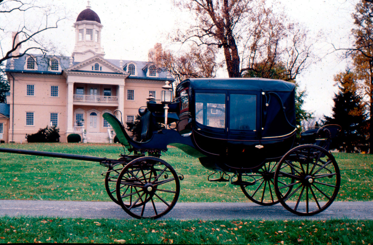
barouche-box
 Similar in style to the modern day convertible, the barouche-box was a four-wheeled carriage with a falling top. It had two sets of double seats, positioned to face each other, and a seat for the driver, called the box, outside of the carriage. Due to its light, somewhat flimsy design, it was regarded as a summer carriage.
-
- Dec 2018
-
en.wikipedia.org en.wikipedia.org
- Oct 2018
-
-
-
Tags
Annotators
URL
-
-
github.com github.com
-
The Linked General Transit Feed Specification (Linked GTFS) is a mapping of the GTFS in CSV reference towards RDF.
Tags
Annotators
URL
-
- Sep 2018
-
Local file Local file
-
transportation in Greater Toronto
Improve urban and peri-urban transportation for LC workers particularly those with low income
-
Transportation
Improve in a timely manner transportation services according to the needs of LDLC workers taking into account those with low income.
-
- May 2018
-
annotatingausten.sfsuenglishdh.net annotatingausten.sfsuenglishdh.net
-
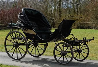
phaeton
"A type of light four-wheeled open carriage, usually drawn by a pair of horses, and having one or two seats facing forward" (OED).
 Image of a light phaeton (Two Nerdy History Girls).
 -
gig
"A light two-wheeled one-horse carriage" (OED).

Image of a Standhope-style gig (Wikipedia).
-
- May 2017
-
annotatingausten.sfsuenglishdh.net annotatingausten.sfsuenglishdh.net
-
curricle
"The fashionable carriage now is a curricle, and the most elegant of that fort is one built by." Times [London, England] 2 Aug. 1787: 3. The Times Digital Archive. Web. 25 Apr. 2017.
This carriage was deemed to be one of the fashionable ones; this could only shed good light on Willoughby and alludes to his class and his fashion style. It was deemed to be an elegant mode of transportation, which helps contribute to the Dashwoods' impression of Willoughby.
-
-
annotatingausten.sfsuenglishdh.net annotatingausten.sfsuenglishdh.net
-
carriage
Horse-drawn carriage used in the 18th and 19th centuries; a status symbol of material wealth used by the upper classes.

-
-
nfnh2017.scholar.bucknell.edu nfnh2017.scholar.bucknell.edu
-
Northern Transportation Company Limited (NTCL)
Northern Transportation Company Limited, which began as Northern Waterways Limited, was a transportation company that assisted in the radium and uranium mining on Great Bear Lake (Prince of Wales Northern Heritage Centre). The company had little assets including two barges and a tugboat. They were acquired by White Eagle Mines in 1934 and their name was changed to Northern Transportation Company Limited (NTCL). In 1936, NTCL was acquired by Eldorado Gold Mines Limited, which also used NTCL to service their mining sites. In 1937, NTCL purchased steel hulled boats for transport. An Eldorado mine closed in 1940, so NTCL began working on the Canol Project in 1942 to transport materials to build a new pipeline. In 1944, the Canadian government took control of NTCL and the company became the main transporter of uranium ore. NTCL took control over the Hudson Bay Company’s transport system in 1947. NTCL also assisted with construction of the DEW line. NTCL was sold to the Inuvaluit Development Corporation and Nunasi Corporation in 1985. NTCL’s main fleet was located at the Port of Hay River in 2015. NTCL was responsible for providing goods to 22 communities through specially designed shallow barges (Government of Canada). NTCL declared bankruptcy on December 30, 2016 and were acquired by Alvarez and Marsal Canada Inc.( Alvarez and Marsal Holdings, LLC).
References: "1934 Northern Transportation Company Limited." Historical Timeline of the Northwest Territories. Accessed May 05, 2017. http://www.nwttimeline.ca/1925/NTCL_1934.html.
"Northern Transportation Company Ltd." Alvarez & Marsal. January 03, 2017. Accessed May 05, 2017. https://www.alvarezandmarsal.com/NTCL#intro.
"Northern Transportation Company Limited." June 22, 2015. Accessed May 05, 2017.
-
-
annotatingausten.sfsuenglishdh.net annotatingausten.sfsuenglishdh.net
-
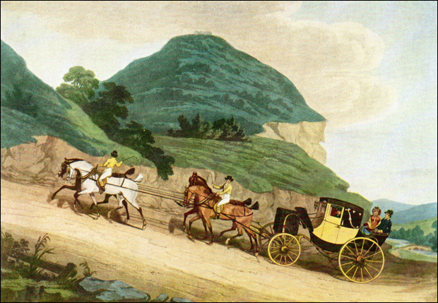
barouche
"A four-wheeled carriage with a half-head behind which can be raised or let down at pleasure, having a seat in front for the driver, and seats inside for two couples to sit facing each other."(OED). "Aristocratic vehicle, for dress occasions, mainly used in town"(Janeite Deb, Jane Austen In Vermont, Travel in Sense & Sensibility~Part IV~Carriages, cont'd, Web)
-
-
annotatingausten.sfsuenglishdh.net annotatingausten.sfsuenglishdh.net
-
chaise
Short for 'post-chaise', defined as ""a horse-drawn, usually four-wheeled carriage (in Britain usually having a closed body, the driver or postilion riding on one of the horses) used for carrying mail and passengers, esp. in the 18th and early 19th centuries"" (OED).
-
- Apr 2017
-
annotatingausten.sfsuenglishdh.net annotatingausten.sfsuenglishdh.net
-
drove about town in very knowing gigs
A gig is "a light two-wheeled one-horse carriage" (OED). Austen is saying these gigs are very fashionable and flashy. These carriages relate lawyers to the association of wealth. Aoife Byrne states that "gigs in Austen's works highlight their owner's social aspirations, and they illustrate contextual attitudes to those aspirations" (Byrne, "'Very Knowing Gigs': Social Aspiration and the Gig Carriage in Jane Austen's Works," Persuasions: The Jane Austen Journal, vol. 37 (2015)).
 . For the lawyers that "drove about" in these carriages, Austen is suggesting the connection of carriages relating lawyers to wealth and fashion.
-
-
www.npr.org www.npr.org
-
Which brings us to the biggest lesson from this survey: If you're mad at an airline, don't complain only to the airline. Complain to the Department of Transportation, too.
Important to note this.
-
-
nfnh2017.scholar.bucknell.edu nfnh2017.scholar.bucknell.edu
-
Alaska Highway
The Alaska Highway was originally constructed for and used by the military during World War II which lasted from 1939 to 1945. It was opened in November of 1942. Its length reached nearly 1,525 miles. When Richard Bucksar wrote his article The Alaska Highway Development published in the journal Arctic Volume 27, Number 1 in 1974, the Alaska Highway had not been paved in its entirety despite many proposals to do so. In 1974, it remained mostly a gravel road described as “rough and uneven” (Bucksar 1974, 74). About 400 of the 1,525 miles were paved.

Since the Alaska Highway passes through Canadian territory to connect the continental United States to Alaska, both country’s governments had to be consulted regarding improvements to the Alaska Highway. The Canadian Parliament and United States Congress were presented with numerous proposals to improve the Alaska Highway including improving the road, developing railways, introducing new sea-routes, reconstructing, paving, etc. (Bucksar 1974, 74-75). Mostly all of these propositions were not passed since alternate “adequate modes of transportation were developing and that the expected traffic on the [Alaska] Highway did not warrant reconstruction and paving at that time” (Bucksar 1974, 78).

The Alaska Highway was the only land-based link between Alaska and the continental United States. Some towns, cities, and other landmarks that the Alaska Highway passes through include Dawson Creek, Fort Saint John, Fort Nelson, Muncho Lake Provincial Park, Liard River Hotsprings Provincial Park, Watson Lake, Teslin, Whitehorse, Halnes Junction, Beaver Creek, Delta Junction, North Pole, Fairbanks, and many more. A detailed current map of the Alaska Highway is displayed below.


References
The Milepost. Alaska Highway. 2016. https://www.themilepost.com/highway-info/highways/alaska-highway (accessed April 4, 2017).
Bucksar, Richard G. "The Alaska Highway Development." Arctic 27, no. 1 (1974): 74-80. http://www.jstor.org.ezproxy.bucknell.edu/stable/40508483.
-
- Jan 2017
-
projects.newyorker.com projects.newyorker.com
-
n 1980, when a transit strike halted buses and subway trains throughout New York’s five boroughs, residents in some of the most marooned parts of the city started using their own cars and vans to pick people up, charging a dollar to shuttle them to their destinations. Eleven days later, the strike ended, but the cars and vans drove on, finding huge demand in neighborhoods that weren’t well served by public transit even when buses and trains were running. The drivers eventually expanded their businesses, using thirteen-seat vans to create routes in places like Flatbush, Jamaica, Far Rockaway, and downtown Brooklyn.
30 year old industry
-
-
www.csail.mit.edu www.csail.mit.edu
-
Transportation studies put the annual cost of congestion at $160 billion, which includes 7 billion hours of time lost to sitting in traffic and an extra 3 billion gallons of fuel burned.
-
- Sep 2016
-
online.salempress.com.lacademy.idm.oclc.org online.salempress.com.lacademy.idm.oclc.org
-
There are approximately 65 airports in El Salvador. However, only Aeropuerto Internacional de El Salvador, located 44 kilometers (27 miles) outside of San Salvador, handles international traffic.
I find that this weird, seeming that is a ton of airports, but there still is only 1 international airport.
-
Public buses are the most common form of public transportation in El Salvador.
This is pretty cool, seeming that not a lot of places actually have public transportation.
-
- May 2016
-
annotatingausten.sfsuenglishdh.net annotatingausten.sfsuenglishdh.net
-
phaetons
 "A type of light four-wheeled open carriage, usually drawn by a pair of horses, and having one or two seats facing forward" (OED).
-
-
annotatingausten.sfsuenglishdh.net annotatingausten.sfsuenglishdh.net
-
a traveling–chaise and four
A traveling chaise was a mode of quick transportation used by rich people, in the eighteenth century. This type of chaise was a closed carriage, which was equipped with four horses. The equipage, which was expensive, was generally composed of two men driving the two horses at the front and sometimes one postilion seated at the back ("Legacy Owensboro").

-
-
annotatingausten.sfsuenglishdh.net annotatingausten.sfsuenglishdh.net
-
sword–case
"A case to hold a sword; in mod. use, a receptacle at the back of a carriage for swords, sticks, or other articles" (OED).
-
Curricle
"A light two-wheeled carriage, usually drawn by two horses abreast" (OED).

-
-
annotatingausten.sfsuenglishdh.net annotatingausten.sfsuenglishdh.net
-
hack post–chaise
An extension of the phrase a hackney horse, a "horse let out for hire; depreciatively, a sorry or worn out horse; a jade" (OED). 'Post-chaise' refers to a "horse-drawn, usually four-wheeled carriage (in Britain usually having a closed body, the driver or postilion riding on one of the horses) used for carrying mail and passengers, esp. in the 18th and early 19th centuries" (OED). Therefore, 'hack post-chaise' means that the entirety of the post-chaise was hired and not owned.
-
- Apr 2016
-
www.theatlantic.com www.theatlantic.com
-
The traffic death toll in 2015 exceeded 3,000 a month.
Car crashes are the leading cause of death for Americans between the ages of 1 and 39.
"Door to Door: The Magnificent, Maddening, Mysterious World of Transportation", Edward Humes
-
- Jan 2016
-
www.theguardian.com www.theguardian.com
-
I only skimmed this, but I think I got the point. You move more people faster on escalators when none of them are reserved for walking -- simply because not enough people are willing or able to walk. If you have walking lanes, they are under-used, and the standing lanes are over-crowded.
-
- Oct 2015
-
cms.whittier.edu cms.whittier.eduuntitled1
-
Despite her small size and old age theMill Baydoeswhat no other ferry in the BC Ferries system does: compete with a highway
The selection of this ferry route allows for an analysis and understanding of island rhythms because people have a choice in taking the ferry or highway. Without an alternative route people on the islands would use the ferries out of necessity. As an alternative route, the Mill Bay makes it possible to examine transportation preferences.
-