222 Matching Annotations
  1. Mar 2024
  2. Feb 2024
  3. Jan 2024
    1. Centrales Hidroeléctricas en Venezuela

      Hydroelectric Power Plants in Venezuela Summary

      This post provides an overview of hydroelectric power in Venezuela. Discussing the different hydroelectric plants in the country. And their significance in electricity generation.

    2. Centrales Hidroeléctricas en Venezuela

      Hydroelectric Power Plants in Venezuela

      • Who: The author, Hanny Marchan, and the community of Hive.
      • What: Sharing information about hydroelectric power plants in Venezuela.
      • Why: To provide information about hydroelectric power plants in Venezuela and discuss their importance and challenges.
      • How: The author explains how hydroelectric power plants work and provides information about specific hydroelectric power plants in Venezuela, including their locations and characteristics. The post also includes images and references.
  4. Dec 2023
  5. Oct 2023
  6. Jan 2023
    1. Khirbet Qeiyafa is located at the western edge of the high Shephelah, in theElah Valley, between Socoh and Azekah (see Fig. 3). In ancient geopoliticalterms, it is situated on the border between Judah and Philistia, dominatingthe main road leading from the Coastal Plain to the hill country and thecities of Hebron, Bethlehem, and Jerusalem.
  7. Dec 2022
    1. Eno was moving toward a music that changed your perception of the space around you. Geography could be as memorable as melody.

      ways to link this to oral traditions in music and memory?!?

  8. May 2022
  9. Feb 2022
    1. But in 618, to punish Pulakeshin for his audacious move on southern Gujarat, Harsha had to cross the Narmada river into the Deccan — which tilted the odds in Pulakeshin’s favour. With his control over the northern Deccan solidified by his of economic and political integration, Pulakeshin could now scout out Harsha’s route of attack and contest the northern emperor’s attempts to cross the great river. Even if Harsha’s larger were to cross the Narmada, this unwieldy force of infantry, cavalry and elephants had to enter the thickly forested Vindhya foothills in order to capture or defeat Pulakeshin — negating their advantage in numbers.

      harsha battle at Narmada Vidhyas foothills

    2. Having expanded his influence as far as Bengal, commanding the ports of India’s east coast, Harsha now wanted to control its west coast as well, linking his territories to flourishing coastal trade routes in both directions. This threat may have been the trigger for the Latas to send tribute to Pulakeshin in place. If so, it was a dangerous gambit: as one scholar puts it, ‘the sovereign of the Deccan must have considered to be his natural birthright… unlimited access to ports of the Gulf of Cambay [Khambat]’.

      Gulf of Khambat

      • importance of port trade in harsha and chalukya period
  10. Dec 2021
    1. Agrigento

      A city on the southern coast of Sicily - there are massive Greek temples still standing there

    2. tuos Mamertinos

      The Mamertines were Roman mercenaries who settled in Messana before the Punic Wars. Messana is on the corner of Sicily closest to the "toe" of Italy.

  11. Nov 2021
    1. நதிக்குள் இருக்கும் நிலப்பகுதி ஆற்றிடைக்குறை எனஅழை க்கப்படுகிறது

      River Island like majuli

  12. Oct 2021
  13. Sep 2021
    1. The Virginians needed labor, to grow corn for subsistence, to grow tobaccofor export. They had just figured out how to grow tobacco, and in 1617 theysent off the first cargo to England. Finding that, like all pleasurable drugstainted with moral disapproval, it brought a high price, the planters, despitetheir high religious talk, were not going to ask questions about something soprofitable.

      Told from this perspective and with the knowledge of the importance of the theory of First Effective Settlement, is it any wonder that America has grown up to be so heavily influenced by moral and mental depravity, over-influenced by capitalism and religion, ready to enslave others, and push vice and drugs? The founding Virginians are truly America in miniature.

      Cross reference: Theory of First Effective Settlement

      “Whenever an empty territory undergoes settlement, or an earlier population is dislodged by invaders, the specific characteristics of the first group able to effect a viable, self-perpetuating society are of crucial significance for the later social and cultural geography of the area, no matter how tiny the initial band of settlers may have been.” “Thus, in terms of lasting impact, the activities of a few hundred, or even a few score, initial colonizers can mean much more for the cultural geography of a place than the contributions of tens of thousands of new immigrants a few generations later.” — Wilbur Zelinsky, The Cultural Geography of the United States, Englewood Cliffs, NJ: Prentice-Hall, 1973, pp. 13–14.

    1. Whistled languages are almost always developed by traditional cultures that live in rugged, mountainous terrain or in dense forest. That’s because whistled speech carries much farther than ordinary speech or shouting, says Julien Meyer, a linguist and bioacoustician at CNRS, the French national research center, who explores the topic of whistled languages in the 2021 Annual Review of Linguistics.

      Rugged mountainous terrain and dense forests show a marked increase in the use of whistled languages as a means of carrying the sound further than ordinary speech or even shouting.

      Who'd have thought that geography would have such an influence on language outside of language spread?

  14. Jul 2021
    1. Anaximander is said to have made the first map of the world. Although this map has been lost, we can imagine what it must have looked like, because Herodotus, who has seen such old maps, describes them. Anaximander’s map must have been circular, like the top of his drum-shaped earth. The river Ocean surrounded it. The Mediterranean Sea was in the middle of the map, which was divided into two halves by a line that ran through Delphi, the world’s navel. The northern half was called “Europe,” the southern half “Asia.” The habitable world (Greek: “oikoumenê”) consisted of two relatively small strips of land to the north and south of the Mediterranean Sea (containing Spain, Italy, Greece, and Asia Minor on the one side, and Egypt and Libya on the other side), together with the lands to the east of the Mediterranean Sea: Palestine, Assyria, Persia, and Arabia. The lands to the north of this small “habitable world” were the cold countries where mythical people lived. The lands to the south of it were the hot countries of the black burnt people.

      Does this map of the world with the black burnt people in the lands to the south (which includes the idea of "below") result in future racist ideas?

  15. Jun 2021
    1. As of 4 September 2020[update], 98 out of 193 (51%) United Nations (UN) member states, 22 out of 27 (81%) European Union (EU) member states, 26 out of 30 (87%) NATO member states, and 31 out of 57 (54%) Organisation of Islamic Cooperation (OIC) member states have recognised Kosovo. The government of Serbia does not recognise it as a sovereign state.
  16. May 2021
  17. Apr 2021
  18. Mar 2021
  19. Feb 2021
  20. Jan 2021
  21. Dec 2020
  22. Oct 2020
  23. Sep 2020
  24. Aug 2020
  25. Jul 2020
  26. Jun 2020
  27. May 2020
    1. “Our country is made up of various smaller countries,” Alves said. “When you walk through Rio de Janeiro, you go through places that have the characteristics of Switzerland to places more like the Congo, all in the same city.”

      On the geography of inequality in Brazil.

  28. Dec 2019
    1. Edinburgh

      The capital of Scotland and home to Edinburgh Castle. The Great North Road was the main mail and passenger routes. from London to York to Edinburgh.

    2. Cumberland lakes

      The Cumberland lakes are part of the Lake District, a mountainous region on the border of Scotland and England.

    3. St. Petersburgh

      One of the northernmost cities in Russia, St. Petersburgh, along with the city Archangel mentioned below, has a name that suggests a journey with theological overtones as Robert Walton moves ever closer on his expedition to his aim of discovering the principle of life, magnetism, and thus symbolically the seat of God.

    4. sometimes rise above the dome of Mont Blânc

      Mont Blanc is the highest mountain in the Swiss Alps, the highest in Europe west of Russia's Caucasus peaks, at about 15,000 feet. It is situated between the regions of Aosta Valley, Italy, and Haute-Savoie, France. It gave Percy Shelley the title of one of his most powerful poems.

    5. We arrived at Havre on the 8th of May

      Havre is in the Normandy region of northwestern France. It is situated on the right bank of the river Seine, on the Channel southwest of the Pays de Caux. It was known for its maritime traditions.

    6. I would have made a pilgrimage to the highest peak of the Andes

      The Andes are the highest peaks in the western hemisphere.

    7. he father of Safie had been the cause of their ruin. He was a Turkish merchant

      Mary Shelley seems to confuse "Turk" with "Arab" here, and more generally her picture of Safie's father as both suffering Christian religious prejudices (against Muslims) and acting as a wily, untrustworthy figure.

    8. Pentland Hills

      Pentland is a range of hills to the south-west of Edinburgh.

    9. Amidst the wilds of Tartary and Russia, although he still evaded me, I have ever followed in his track

      Tartary was a vast, cold country in the northern parts of Asia, bounded by Siberia on the north and west. A vast tract of land in northern and central Asia, it stretched from the Caspian Sea and the Ural Mountains to the west, all the way to the Pacific Ocean in the east. It was inhabited mostly by Mongol peoples.

    10. Perth

      Perth is an ancient town on the River Tay in Scotland, about 44 miles north of Edinburgh.

    11. below Mayence

      The region south of Mayence might be more picturesque because of the Kühkopf-Knoblochsaue, now a well-known nature preserve.

    12. r by ascertaining the secret of the magnet

      We now know that the magnetic charge of the North Pole causes the needle of a compass to point north. However, until William Gilbert (1540-1603) discovered the magnetism of the earth's poles, it was a common conception that the needle on the compass moved by force of magic. In Shelley's time, the source of the earth's magnetism was a mystery and adventurers like Robert Walton set out to the North and South Poles seeking scientific answers and public glory.

    13. St. Bernard’s Well

      St. Bernard's Well, a circular Roman-style structure, was built in 1789 to a design by celebrated Edinburgh landscape painter Alexander Nasymth drawing inspiration from the Temple of Vesta at Tivoli in Italy. It is on the Water of Leith in Dean Private Gardens.

    14. cape of Africa or America?

      Robert will return to England by way of the Cape of Good Hope (South Africa) or the Cape Horn (South America).

    15. Gravesend, Woolwich, and Greenwich, places which I had heard of even in my country.

      Gravesend is an ancient town in northwest Kent, England. Woolwich was also originally a town in Kent. Greenwich is an area of south east London, England, near Charing Cross.

    16. Chamounix

      Situated near the peaks of the Aiguilles Rouges, Chamounix faces the north side of the summit of Mont Blanc. Picturesque, Chamounix was the host of the first Winter

    17. I arrived at Strasburgh,

      Strasburgh, or more commonly Strasbourg, is the capital of the Grand Est region of France, the official seat of the European Parliament. It is located close to the border with Germany in the historic region of Alsace. In Shelley's day, Strasburgh was a well-known center of humanism, at the crossroads of French and German intellectual traditions.

    18. we saw Mont Salêve, the pleasant banks of Montalêgre, and at a distance, surmounting all, the beautiful Mont Blânc

      The Salève is a mountain of the French Prealps. It is also called the "Balcony of Geneva."

    19. Jura

      The Jura Mountains are a sub-alpine mountain range to the north of the Western Alps, along the border of Switzerland and France.

    20. the pallid lightning that played above Mont Blanc, and listening to the rushing of the Arve

      Rising in the northern side of the Mont Blanc in the Alps, the river Arve receives water from the many glaciers of the Chamounix valley. The river is known for its frigid waters.

    21. And now my wanderings began

      "Guided by a slight clue," Victor tracks the monster from Geneva along the windings of the Rhone southward to the Mediterranean. He spots the monster hiding in a ship and follows him to the Black Sea, through the wilds of Tartary and Russia. Ultimately, he travels northward into the ice.

    22. and the field on which that patriot fell.

      Victor is referring to Chalgrove Field in Oxfordshire, where the revolutionary leader John Hampden was fatally wounded in a battle with Royalist leader Prince Rupert.

    23. I am by birth a Genevese

      Born in Geneva, Switzerland, Victor is a potential hero insofar as he embodies the "republican" virtues of Europe's only country, much admired by the Shelleys, which did not have a hereditary monarchy. By making Geneva so central to the novel's cultural geography, Mary Shelley also designates the relation between Victor's ambition and Jean Jacques Rousseau's world-making ambition in Discourse on Inequality (1754) among other works.

    24. I have seen the mountains of La Valais, and the Pays de Vaud

      La Valais is an extremely mountainous region that includes the highest mountains in Switzerland. The highest mountain ranges are the Pennine Alps, the Bernese Alps, and the Mont Blanc. The Pays de Vaud, on the other hand, is partly mountainous, though visually arresting, having summits of about 3,000 meters.

    25. Matlock

      Matlock is a county town in Derbyshire, just to the north of Matlock Bath, a former spa town.

    26. Derby

      Derby, England is a city lying on the banks of the River Derwent, Derbyshire.

    27. I followed the windings of the Rhone

      Victor followed the Rhone as it winded its way south, toward the Mediterranean.

    28. Arthur’s Seat

      Arthur's Seat is a main peak of a group of hills in Edinburgh, Scotland.

    29. aiguilles

      Aiguilles is French for "pinnacle of rock."

    30. Mayence

      Mainz (French: Mayence) is the capital and largest city of Rhineland-Palatinate, Germany. The city is located on the Rhine river at its confluence with the Main river, opposite Wiesbaden on the border with Hesse.

    31. Lucerne

      Known for its number and length of bridges, Lucerne had a population of about 100,000 in the 1797 census. Almost exclusively Catholic, it was situated in the German-speaking region of Switzerland. It remains highly scenic, framed by mountains and lakes.

    32. Orkneys

      The Orkney Islands lie along the north-east coast of Scotland.

    33. its romantic castle,

      Victor means Edinburgh Castle, a historic fortress presiding over the city of Edinburgh, Scotland, and built as early as the 12th Century.

    34. Montanvert

      Montanvert, also known as Mer de Glace (French for 'sea of ice"), is one of the three major glaciers on Mont Blanc.

    35. Isis

      Isis is the former name for the section of the Thames that flows from Gloustershire to Dorchester-on-Thames.

    36. plains of Holland

      The landscape in southern Holland is mainly flat and strewn with lakes and canals. Since most of the Netherlands is low-lying, with nearly half of the land at or below sea level, it was commonly referred to at the time as "the plains of Holland."

    37. The country in the neighbourhood of this village resembled, to a greater degree, the scenery of Switzerland

      Victor's decision to tour the English countryside, rather than take the fastest road to Edinburgh, affords his party the chance to compare English geography to Europe's and they do so it considerable detail, beginning with this comparison of the country around Matlock to Switzerland. Matlock was south of the industrial cities of Manchester and Leeds, but it is on the way to the Lake District in Victor's northern tour.

    38. Oxford

      Oxford, England city in the county of Oxfordshire. It is home to the oldest English university, the University of Oxford.

    39. the river Arve

      The Arve flows through Chamounix, Sallanches, Oëx, Cluses, Bonneville, Annemasse and Geneva.

    40. voyages which have been made in the prospect of arriving at the North Pacific Ocean

      Both commercial and scientific voyages had been searching for a Northwest passage or open seaway between the Atlantic and Pacific oceans. For the Arctic context of the novel, see Adriana Craciun, "Writing the Disaster: Franklin and Frankenstein," Nineteenth-Century Literature 65.4 (2011): 433-80.

    41. Coupar

      Coupar is a town 13 miles to the north of Perth, Scotland.

    42. We had agreed to descend the Rhine 014in a boat from Strasburgh to Rotterdam

      Strasburgh and Rotterdam are separated by about 600 miles of river. It would have taken the party about a week to traverse this distance on the Rhine by boat or barge in the nineteenth century.

    43. I have visited the lakes of Lucerne and Uri

      Lake Lucerne is a lake in central Switzerland and the fourth largest in the country. Lake Uri, also in Switzerland, is known for its reflective blue waters.

    44. A house was purchased for us near Cologny

      Cologny, a small town in Switzerland, is approximately one hour's walk to the east of Geneva.

    45. The season was cold and rainy

      In 1816 the eruption of the volcano Mount Tambora (Indonesia) created extreme weather around the world in what came to be called "the year without a summer." See Gillen D'Arcy Wood, Tambora: The Eruption that Changed the World (New Jersey: Princeton University Press, 2015). Food shortages and cold affected millions of Europeans.

    46. Archangel.

      Archangel is the anglicized name for the town of Arkhangelsk, a large seaport in northern Russia.

    47. we passed the river Drance

      The river Drance empties into Lake Geneva between Thonon-les-Bains and Évian-les-Bains.

    48. Mont Cenis

      Mont Cenis is a massif in France, which forms the limit between the Cottian and Graian Alps.

    49. Reuss

      The Reuss is the fourth-largest river in Switzerland, after the Rhine, Aare and Rhôn.

    50. we proceeded to Oxford

      No university in Europe could have been more the opposite of the University of Ingolstadt (where Victor learned his science) than Oxford University, the seat of theological learning and a holdout against any form of Enlightenment sciences. Victor is also initially nostalgic for the days of Charles I when the absolute monarch was beleaguered in the early years of the English Revolution (1642-1659). He later praises the republican opponent of Charles I, John Hampden. What version of England's political past Mary Shelley means to commemorate in this chapter remains an interesting question.

    51. The spire of Evian

      Evian-les-Bains is a resort and spa on Lake Geneva near Lausanne. Today it is famous for its commercially successful bottled mineral waters.

    52. hide himself in a vessel bound for the Black Sea

      Victor sails northeast toward the Black Sea, whose far shore is Russia.

    53. wondrous cave,

      Victor refers to the Great Masson Caverns on the Heights of Abraham above Matlock Bath.

    54. Holyhead

      Holyhead is a town in Wales and serves as a major port in the Irish Sea.

    1. A tingling long-lost sense of pleasure often came across me during this journey. Some turn in the road, some new object suddenly perceived and recognised, reminded me of days gone by, and were associated with the light-hearted gaiety of boyhood. The very winds whispered in soothing accents, and maternal nature bade me weep no more. Then again the kindly influence ceased to act—I found myself fettered again to grief, and indulging in all the misery of reflection. Then I spurred on my animal, striving so to forget the world, my fears, and, more than all, myself—or, in a more desperate fashion, I alighted, and threw myself on the grass, weighed down by horror and despair. At length I arrived at the village of Chamounix. Exhaustion succeeded to the extreme fatigue both of body and 80of mind which I had endured. For a short space of time

      In the 1831 edition, since Victor now travels alone rather than with his family, his perceptions seem to be more emotionally turbulent than when he shares the trip with Elizabeth and his father in the 1818 version.

    2. a wet, ungenial summer

      Mary Shelley understates the weather emergency in 1816, which was often called "the year without a summer." Following the eruption of Mt. Tambora in Indonesia, Europe's weather turned cold and wet enough to destroy crops and induce famine among populations across the continent. For a vivid account, see Gillen D'Arcy Wood, Tambora: The Eruption that Changed the World (Princeton University Press, 2014).

    3. northern shores of the Tay, near Dundee

      Scotland's longest river, the River Tay extended from western Scotland to the town of Dundee on the east coast.

    4. The voyage came to an end. We landed, and proceeded to Paris. I soon found that I had overtaxed my strength, and that I must repose before I could continue my journey. My father’s care and attentions were indefatigable; but he did not know the origin of my sufferings, and sought erroneous methods to remedy the incurable ill. He wished me to seek amusement in society. I abhorred the face of man. Oh, not abhorred! they were my brethren, my fellow beings, and I felt attracted even to the most repulsive among them, as to creatures of an angelic nature and celestial mechanism. But I felt that I had no right to share their intercourse. I had unchained an enemy among them, whose joy it was to shed their blood, and to revel in their groans. How they would, each and all, abhor me, and hunt me from the world, did they know my unhallowed acts, and the crimes which had their source in me! My father yielded at length to my desire to avoid society, and strove by various arguments to banish my

      In all editions but the 1831, Victor says he wished to avoid London because he "dreaded to see again those places in which [he] had enjoyed a few moments of tranquility with [his] beloved Clerval." The 1831 edition makes no mention of Clerval; now Victor's father entreats his son to seek solace in the company of society, which Victor refuses, out of guilt and his guilt at unleashing "an enemy among them." Also eliminated in 1813 are references to stopping at the ports of Holyhead and Portsmouth on their way to Paris.

    5. I spent the following day roaming through the valley. I stood beside the sources of the Arveiron, which take their rise in a glacier, that with slow pace is advancing down from the summit of the hills, to barricade the valley. The abrupt sides of vast mountains were before me; the icy wall of the glacier overhung me; a few shattered pines were scattered around; and the solemn silence of this glorious presence-chamber of imperial Nature was broken only by the brawling waves, or the fall of some vast fragment, the thunder sound of the avalanche, or the cracking, reverberated along the mountains of the accumulated ice, which, through the silent working of immutable laws, was ever and anon rent and torn, as if it had been but a plaything in their hands. These sublime and magnificent scenes afforded me the greatest consolation that I was capable of receiving. They elevated me from all littleness of feeling; and although they did not remove my grief, they subdued and tranquillised it. In some degree, also, they diverted my mind from the thoughts over which it had brooded for the last month. I retired to rest at night; my slumbers, as it were, waited on and ministered to by the assemblance of grand shapes which I had contemplated during the day. They congregated round me; the unstained snowy mountain-top, the glittering pinnacle, the pine woods, and ragged bare ravine; the eagle, soaring amidst the clouds—they all gathered round me, and bade me be at peace.

      In 1818 a more perfunctory passage appears at the beginning of this chapter stating simply that the party "...visited the source of the Arveiron, and rode about the valley until evening."

      In 1831, Shelley replaces this brief remark with a much more vividly detailed description elaborating upon the topography of Victor's journey through the Arveiron and the "sublime and magnificent scenes" in which he finds consolation.

    6. From Italy they visited Germany and France. I, their eldest child, was born at Naples

      In the 1818 edition Victor says that he was "by birth a Genevese," his only reference to his own birth. The implication there is that he was born in Geneva, but the 1831 edition instead places his birth in Naples. Soon afterward we learn that when his family discovered Elizabeth, her mother is Italian.

    7. Through my father’s exertions, a part of the inheritance of Elizabeth had been restored to her by the Austrian government. A small possession on the shores of Como belonged to her. It was agreed that, immediately after our union, we should proceed 172to Villa Lavenza, and spend our first days of happiness beside the beautiful lake near which it stood.

      In earlier editions, a house is purchased for Victor and Elizabeth, presumably by Victor's father. However, in the 1831 edition, Victor's father petitions the Austrian Government for return of Elizabeth's inheritance. The change appears to be in error, since Shelley explains that Villa Lavenza sits on the shores of Lake Como, though the borders of Austrian Empire (1804-1867) did not extend as far as Lake Como.

    8. the dashing waves were around: the cloudy sky above; the fiend was not here: a sense of security, a feeling that a truce was established between the present hour and the irresistible, disastrous future, imparted to me a kind of calm forgetfulness, of which the human mind is by its structure peculiarly susceptible.

      In earlier editions, Victor's father calms him by pointing to the approach of their next port at Holyhead, a Welsh port in the Irish Sea. This reference, along with a reference to stopping in Portsmouth, England, disappears in this 1831 revision, replaced by Victor's shuddering at the "disastrous future" looming before him. The journey toward Paris now appears to have no stopping points in the United Kingdom.

    9. Havre-de-Grace

      The 1831 edition records the place as "Havre-de-Grace," which appears simply as "Havre" in earlier editions. Havre is in the Normandy region of northwestern France. It is situated on the right bank of the river Seine, on the Channel southwest of the Pays de Caux. It was known for its maritime traditions.

    10. commence our journey by water, sleeping that night at Evian, and continuing our voyage on the following day. The day was fair, the wind favourable, all smiled on our nuptial embarkation.

      In earlier versions, Victor and Elizabeth travel to Evian, a resort on Lake Geneva near Lausanne, for the evening before returning to Cologny the next morning. In the 1831 edition, the couple spend the night in Evian before traveling to Villa Lavenza on Lake Como the following day, but there is no mention of their return to Cologny.

    11. the river Drance

      The Drance river near Evian extends about 30 miles through Switzerland and converges with the Rhone River.

  29. Oct 2019
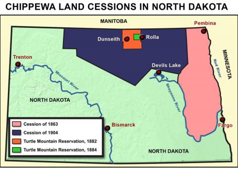
    1. Chippewa reservation

      Chippewa reservation is one of the biggest natives live in Northern America. They are often called as Ojibway Indians, also being one of the largest groups of American Indians in North America. There are nearly 150 different bands of Chippewa in the northern part of the United States and in southern Canada.

    2. Van Cortlandt Park

      A park in the Bronx.

    3. Bronx

      Alexandria ocasio Cortez's county. also third most populous county in the U.S.

    4. Greenwich Village

      It's a neighborhood in Manhattan, and is notoriously expensive to live. The prices would be comparable to Shanghai's sky-high prices. Heck, it's so notable it's simply known as "the village" by locals.

      Source from https://en.wikipedia.org/wiki/Greenwich_Village.

    5. New England

      New England is a region compose of six states in the U.S.

      The region played a critical role of abolishing slavery in the country. It is also the first region shifting by the Industrial Revolution.

      Source from https://en.wikipedia.org/wiki/New_England.

    6. Bellevue

      Bellevue is a city in the Eastside region of King County, Washington, United States, across Lake Washington from Seattle. It is well known for its rapid growing within preserving its suburban aspect.

    7. North Dakota

      It is a U.S. state where its capitalBismarck and its largest city is Fargo.

      Source from https://en.wikipedia.org/wiki/North_Dakota.

    8. Cold Spring Harbor

      Cold Spring Harbor rose as a whaling community in the mid-nineteenth century. But after the decline of the whaling industry, it became a resort town in the1860s. Source from https://en.wikipedia.org/wiki/Cold_Spring_Harbor,_New_York.

    9. Norwood

      Norwood was long used as a hunting ground by Native Americans and was settled by the English in 1678. It is located in Norfolk County, Massachusetts, United States as part of Great Boston area. See the location on the map below.

      Source from https://en.wikipedia.org/wiki/Norwood,_Massachusetts.

    10. Alaska

      Alaska is the northernmost and the westernmost state in the United States as the only noncontiguous state on continental North America. See the location on the map below. Source from https://en.wikipedia.org/wiki/Alaska.

  30. Sep 2019
  31. May 2019
    1. Hertfordshire

      "A county of south-eastern England, one of the Home Counties; county town, Hertford" (OED).

    2. Kent

      "A county of the south-eastern coast of England; county town, Maidstone" (OED). .jpg&action=MediaGallery)

    3. Rosings

      Fictional estate of Lady Catherine located in Kent, near Hunsford Parsonage.

      Image of the set of the 1995 BBC version of Pride & Prejudice.

    4. Parsonage

      "The church house provided for a rector...the house of any beneficed member of the clergy of the Church of England; the residence of any minister of religion" (OED).

  32. Apr 2019
    1. Isle of Wight

      The Isle of Wight is an island off the south coast of England. It’s known for its beaches and seafront promenades.

    2. Burton on Trent

      Burton on Trent (also called Burton upon Trent) is a major brewery town on the River Trent in East Staffordshire, England. It was known for producing foodstuffs, hosiery, knitting machines, and steel goods.

    3. Chichester

      a city of of West Sussex in South-East England, approximately six miles from the nearest coast

    1. The Piri Reis map is a world map compiled in 1513 from military intelligence by the Ottoman admiral and cartographer Piri Reis (pronounced [piɾi ɾeis]). Approximately one third of the map survives; it shows the western coasts of Europe and North Africa and the coast of Brazil with reasonable accuracy. Various Atlantic islands, including the Azores and Canary Islands, are depicted, as is the mythical island of Antillia and possibly Japan. The map's historical importance lies in its demonstration of the extent of global exploration of the New World by approximately 1510, and in its claim to have used a map of Christopher Columbus, otherwise lost, as a source. Piri also stated that he had used ten Arab sources and four Indian maps sourced from the Portuguese. More recently, the map has been the focus of claims for the pre-modern exploration of the Antarctic coast.
  33. Feb 2019
  34. Dec 2018
  35. Oct 2018
  36. Aug 2018
    1. "As these various commentaries suggest, teaching itself carries a moral dimension. Indeed, Professor Bernard Crick, a member of the UK Government's citizenship advisory group, has identified geography as having a

      potential role to play in teaching political liter- acy and social and moral responsibility (Lambert, 1999)." 489.

    2. "Cloke's solution is for geographers to develop stronger connections between their

      academic and nonacademic lives. His argu- ment echoes Robin Kearns' (2001) earlier call

      for a more 'compassionate geography' (see also Smith, 1998; Gleeson and Kearns, 2001) as

      well as feminist refrains ofthe 'personal is polit- ical and slogans such as 'act local, think global'." 484

    3. Doreen Massey junto A Cloke y a Martin (2001): "Although Doreen Massey (2002) balks at the inference that the only way to be politically or socially relevant is to produce answers for government and inform government policy, she too recognizes the need for geographers to be more engaged

      beyond the academy and to construct popu- lar and political geographical imaginations." 284

    4. "identifies a tension between the ease with which we talk and write about geographies of ethics," 483

  37. www.dropbox.com www.dropbox.com
    1. As Glacken points out, Plato missed the chance to change the whole history of speculation concerning man-land relations by identifying the individual as destructive agent.

      “As Glacken points out, Plato missed the chance to change the whole history of speculation concerning man-land relations by identifying the individual as destructive agent.” (P. 24)

    2. At least five different kinds of questions of geographic character can be investi­gated: (1

      5 preguntas: Genéricas: con un vasto compendio de herramientas conceptuales que requiere para no perderse. Genéticas: Tienen que ver con los cambios geográficos en el tiempo. Tiene que ver con geografía histórica Teoréticas: Que juegan entre métodos deductivos e inductivos Remediales: Que buscan aplicar conceptos de la geografía a problemas concretos en el campo social, económico, político. Metodológicas: Que tienen que ver con la experimentación de nuevos métodos de estudio, nuevas técnicas de observación o análisis y nuevos métodos cartográficos

    3. geographer is a person who asks questions about the significance of place, location, distance, direction, spread, and spatial succession. The geographer deals with problems of accessibility, innovation diffusion, density, and other derivatives of relative location

      Qué hace un geógrafo?

      “Geography has always had a holistic tradition, so that it comes as no intellectual shock to study systems or interconnected parts of diverse origin. Geography is closed involved with cartography in the development and use of maps, which are ideally suited that are ideally suited to the study of complex location factors. A geographer is a person who ask questions about the significance of place, distance, direction, spread and spatial succession. The geographer deals with problems of accesibility, innovation diffusion, density, and other derivatives of relative location.” 8

    4. The first amazing period of intellectual ferment that is part of the written tradi­tion of the Western world took place in ancient Greece, culminating in the fourth and third centuries b.c

      El primer momento de fermento inteleectual en el mundo occidental entre la grecia antigua y el 4 y 5 siglo antes de cristo

    5. The new geography began in Germany in 1874, when departments of geography headed by scholars with the rank of professor were established in the German universities.

      1874-> Inicio de la geografía moderna con el establecimiento de departamentos de geografía en Alemania. Luego Francia, Gran Bretaña y Rusia. Estados Unidos

    6. To create a professional field, three conditions had to be satisfied.

      Tres condiciones para un campo profesional:

      1. Un cuerpo de conceptos, imágenes y una forma particular de hacer preguntas.
      2. Existencia de asociaciones, publicaciones y departamentos que impartan la disciplina
      3. Que exista un campo de acción en el que a los egresados de las escuelas les les pague por lo que hacen
    7. Two major periods are defined. The first period extends for thousands of years from the shadowy beginnings of geographical thought to the year 1859. This is the classical period, during which relatively little attention was paid to the definition of separate fields of study

      Periodos de la historia de la geografía Clasico: Hasta 1859

    1. his importance liesboth in the way he understands geography as a coun-terbalance to history, and in terms of the organization ofknowledge. For Kant, all perceived things are located inlogical classifications, such as those of Linnaeus; and inspace and time.

      Geografía como contrapeso de la historia

    2. This leads Kant to what he calls ‘moralgeography,’ which looks at the customs and characters ofdifferent peoples and some outdated and discreditedviews of race. K
    3. Space and time are, therefore,determined in advance in Kant’s thought, the materialworld is understood before it is experienced, and there-fore, what we experience is conditioned by our priorknowledge.

      "Espacio y tiempo son parte de nuestro aparato peceptivo, pero no podemos experimentar el espacio y el tiempo" para fraseando, sacar varias conclusiones importantes para el conocimiento: usamos herramientas para entender el mundo antes de experimentarlo y la forma en que lo hacemos está determinada por nuestro entendimiento. En otras palabras, experimentamos según lo que entendemos

    4. e suggests, cruciallyfor geographers, that space and time area prioriconcepts– that is they precede experience – which serve tostructure the world we perceive. He calls these thetranscendental esthetic, from the Greekaisthesis, per-ception.

      Para la geografía, espacio y tiempo son conceptos a priori

  38. Jun 2018
  39. May 2017
    1. Trans-Mountain oil pipeline

      This is a very controversial oil pipeline that runs from Edmonton to Vancouver. This pipeline was built in the 1950s by Kinder Morgan in order to bring oil from Alberta to British Columbia when large oil deposits were discovered. This pipeline had a lot of political drive behind not only from the Canadian government but also the United States who wanted easier oil access on the west coast. The United States was in the middle of the Korean War and wanted to have more secure oil contact. The pipeline had a lot of resistance from other environmentalist groups because it ran through areas that would later be named national parks. However today, there is another pipeline that is being proposed by Kinder Morgan that runs almost parallel to the pre-existing one. The intent of the new pipeline is to bring more oil to the west coast of Canada in order to keep up with the growing oil market in Asia. The new pipeline was approved by British Columbia in January 2017 but the decision immediately faced resistance from the public. Many people are skeptical of a new pipeline because of Kinder Morgan's track record with spills in the past. A journalists from Vancouver writes "British Columbians will continue to fight this decision in the courts and on the streets well past next spring's election." This pipeline is a good example compared to the Mackenzie Valley Pipeline that is in a similar situation right now. There has been a new pipeline proposed there as well that is supported by the oil companies but many citizens and environmental groups are resisting it. "British Columbia nod to pipeline expansion." Oil & Gas News, January 16, 2017. Global Reference on the Environment, Energy, and Natural Resources (accessed May 7, 2017). http://find.galegroup.com/grnr/infomark.do?&source=gale&idigest=6f8f4a3faafd67e66fa023866730b0a1&prodId=GRNR&userGroupName=bucknell_it&tabID=T004&docId=A477938750&type=retrieve&PDFRange=%5B%5D&contentSet=IAC-Documents&version=1.0. "Kinder Morgan - EHS - Pipeline Safety." HOUWWWP1. Accessed May 07, 2017. http://www.kindermorgan.com/pages/ehs/pipeline_safety/default.aspx.

    2. Alberta-British Columbia

      Alberta-British Columbia is a region in south western Canada. This region is where the proposed pipeline would be travelling through to get to the lower parts of Canada and Vancouver as well as the United States. This region is home to foothill forests which are very interesting ecosystem that is only found at this latitude. The foothill forests border the Canadian taiga forests from the north and the temperate forests from the south. This combination makes the foothill forests a very unique community which is known as an ecotone because it works as a buffer in between two other ecosystems. This ecosystem is home to a variety of fauna such as moose, reindeers, snowshoe hares, and beavers. This area is home to the most abundant moose populations in the world. Forests have become increasingly vulnerable to mortality due to the direct and indirect effects of climate change and human activity. "In Western Canada, recent increases in the frequency and severity of natural disturbances in forests, such as wildfires, pest outbreaks, and droughts, have been attributed to a changing climate" Like many other ecosystems in the north, the foothill forests are facing major problems due to climate change. Moose populations are dropping due to new diseases that are prevalent because of the warmer year round temperatures. This phenomenon is being experienced all over the northern part of the United States and southern Canada.

      Hajjar, Reem, and Robert A. Kozak. "Exploring public perceptions of forest adaptation strategies in Western Canada: Implications for policy-makers." Forest Policy and Economics 61 (2015): 59+. Global Reference on the Environment, Energy, and Natural Resources (accessed May 6, 2017). http://find.galegroup.com/grnr/infomark.do?&source=gale&idigest=6f8f4a3faafd67e66fa023866730b0a1&prodId=GRNR&userGroupName=bucknell_it&tabID=T002&docId=A437244896&type=retrieve&PDFRange=%5B%5D&contentSet=IAC-Documents&version=1.0.

  40. Apr 2017
    1. If you do want synchronization , this is the default, so you can simply continue by pressing the Add button to add the next tab. I

      I was wondereing if we could add pop-ups for points if incase we missed a point mapping in GeoJson. Thank you

  41. Feb 2017
  42. Jan 2017
    1. landed at Malaga the first place where she heard of your worship was Osuna.”

      mention of real paces still existing today.

    1. n a village of La Manch

      Don Quixote is from a village called La Mancha of Spain. This village is where the story begins and plays a large part in who Don Quixote is. From this village Don Quixote was quipped, by himself, as Don Quixote de La Mancha.

  43. Oct 2016
  44. Aug 2016
    1. California Crisis

      Geographical limiters and case studies.

    2. California prison situ-ation represents an extremeversion of what many pris-oners’-rights advocates andlaw-enforcement officials calla national crisis created by thenation’s incarceration boom

      Look for specific geographical regions that may help focus your topic or supply specific case studies, examples, or stories.

  45. Jul 2016
    1. Languedoc

      A territory in the south of France.

    2. Fonterabia

      Also Fuenterrabia or Hondarribia, a town on the west shore of the Bidasoa River's mouth in Spain.

    3. Bourdeaux

      A port city on the Garonne River in southwestern France.

    4. Pampeluna

      Pamplona, the capital city of Navarre. (Navarre itself is an autonomous community within Spain.)

    5. Rochell

      La Rochelle, a seaport city in France adjacent to the Bay of Biscay.

    6. Bay of Biscay

      A bay off the coast of Europe, adjacent to France and Spain.

    7. Torbay

      A borough in Devon in the southern coast of England.

    8. Algerine

      People from Algeria

    9. Leeward Islands

      A cluster of small islands east of Puerto Rico, including the modern US and British Virgin Islands and Guadeloupe.

    10. Alicant

      A Spanish port city on the Costa Blanca

    11. Islands

      Caribbean

    12. New Spain

      Spain's New World land holdings, spanning modern-day Mexico, the southwestern United States, and northern regions of South America

  46. Jun 2016
  47. May 2016
    1. Leaden-hall Market

      A covered market in Gracechurch Street, London, dating from the fourteenth century

    2. Spanish Dominions

      Spain's colonies at this time included Venezuela and Colombia, so Crusoe's island is probably located off the northern coast of South America.

    3. W. S. W.

      West-southwest

  48. Mar 2016
    1. 9 Degrees 22 Minutes North

      The 9th parallel north intersects both Colombia and Venezuela, from which we can estimate that Crusoe's island is somewhere off the northern coast of South America. [Insert map here.]

    2. Carrible-Islands

      Caribbean islands