187 Matching Annotations
- Feb 2026
-
www.kickstarter.com www.kickstarter.com
- Nov 2025
-
www.nytimes.com www.nytimes.com
-
There was a moment, in time, and in this place, when my brother, or my mother, or my father, or my sister, had to convey to me, for example, the danger in which I was standing from the white man standing just behind me, and to convey this with a speed, and in a language, that the white man could not possibly understand
What this shows: Communicative function of Black English for safety/solidarity; opacity to dominant listeners.
How I’ll connect it later: purpose-driven language (Baldwin) / Young’s claim that “It’s ATTITUDES,” not dialect deficits.
-
Subsequently, the slave was given, under the eye, and the gun, of his master, Congo Square, and the Bible — or, in other words, and under these conditions,.the slave began the formation of the black church, and it is within this unprecedented tabernacle that black English began to be formed.
Baldwin’s historical account of Black English’s formation complements Heller’s analysis of AAVE as identity/agency in Bambara—both center vernaculars as purposeful, not deficient.
-
Subsequently, the slave was given, under the eye, and the gun, of his master, Congo Square, and the Bible — or, in other words, and under these conditions,.the slave began the formation of the black church, and it is within this unprecedented tabernacle that black English began to be formed.
What this shows: Specific historical sites (church/community) where Black English coalesced.
How I’ll connect it later: historical formation (Baldwin) / AAVE-as-agency in literature (Heller).
-
It is not the black child's language that is in question, it is not his language that is despised: It is his experience.
Baldwin’s “it is his experience” aligns with Young’s language-justice stance and Alvarez/Wan/Lee’s translingual pedagogy—value lived experience and plural voice over monolingual “objectivity.”
-
It is not the black child's language that is in question, it is not his language that is despised: It is his experience.
Why this quote matters: Reframes “standards” as hostility to lived experience, not grammar.
Signal phrase I might use: Baldwin insists, “It is his experience.”
-
It is the most vivid and crucial key to identity: It reveals the private identity, and connects one with, or divorces one from, the larger, public, or communal identity.
Where Jenkins argues SAE mastery for workplace power, Baldwin reframes power as already embedded in Black English’s identity/politics—setting up a productive tension for synthesis.
-
It is the most vivid and crucial key to identity: It reveals the private identity, and connects one with, or divorces one from, the larger, public, or communal identity.
Why this quote matters: States language–identity linkage for synthesis. Signal phrase I might use: Baldwin maintains that language is “the most vivid and crucial key to identity…”
-
-
drive.google.com drive.google.com
-
To start writing this chapter, for example, one of the first things we didwas read previous contributions to Writing Spaces to get a sense of the ex-pected tone and the structure.
What the example demonstrates: Audience/design analysis as part of language-architect work.
How I will connect it later: situational design (Alvarez/Wan/Lee) / Jenkins’s emphasis on audience expectations (contrast in aims).
-
Once we havesome words, ideas, frustrations on paper, we give ourselves small writingtasks, like “just write whatever you can or feel about X topic for 5 minutes.”
Pedagogy in action: The authors’ translingual strategies (freewriting, revision cycles) complement Young’s call to teach descriptively and embrace code meshing in the same paper.
-
Once we havesome words, ideas, frustrations on paper, we give ourselves small writingtasks, like “just write whatever you can or feel about X topic for 5 minutes.”
What the example demonstrates: A concrete technique that surfaces authentic voice before later shaping.
How I will connect it later: practice-level support for translingual composing / Young’s classroom stance on descriptive teaching.
-
What we mean bythis is that your voice and all the ways you use it—as part of who you are—makes all the difference, and therefore, should be amplified and cultivated.
Why this quote matters to my theme: Centers student voice as a positive resource to develop, not suppress.
Signal phrase I might use: The chapter emphasizes that “your voice… should be amplified and cultivated.”
-
Yes, you read this correctly: standard written English is not an objectiveset of criteria.
Standard vs. plurality: This chapter challenges the “objective” status of standard written English, contrasting with Jenkins’s claim that mastering a single standard is central to professional success.
-
Yes, you read this correctly: standard written English is not an objectiveset of criteria.
Why this quote matters to my theme: Directly challenges “objective standard” myths that drive gatekeeping.
Signal phrase I might use: The authors assert, “standard written English is not an objective set of criteria.”
-
-
pubs.lib.uiowa.edu pubs.lib.uiowa.edu
-
Teachers frequently encounter him on panels with titles like“The Expanding Canon: Teaching Multicultural Literature InHigh School.” But the dude is also hella down to earth.
Vernacular as agency: Young’s code meshing aligns with Heller’s claim that AAVE conveys identity, confidence, and critique; both position vernacular forms as tools of voice and resistance.
-
Teachers frequently encounter him on panels with titles like“The Expanding Canon: Teaching Multicultural Literature InHigh School.” But the dude is also hella down to earth.
What the example demonstrates: Journalistic prose mixing formal description with vernacular insertions—live code meshing in print.
How I will connect it later: identity/voice via vernacular (Young) / AAVE-as-agency (Heller).
-
(1) Iowa Republican Senator Chuck Grassley sent two tweets to President Obamain June 2009 (Werner).
Pragmatics vs. plurality: Young promotes blending codes in public/professional writing (e.g., Grassley tweets), while Jenkins urges mastery of a single standard for workplace credibility.
-
(1) Iowa Republican Senator Chuck Grassley sent two tweets to President Obamain June 2009 (Werner).
What the example demonstrates: Public, professional communication already blends registers/abbreviations—evidence of code meshing beyond classrooms.
How I will connect it later: real-world register mixing (Young) / workplace register expectations (Jenkins).
-
Instead of prescribing how folks should write or speak, I say we teach languagedescriptively.
Why this quote matters to my theme: Sets the teaching stance that supports code meshing.
Signal phrase I might use: Young proposes, “we teach language descriptively.”
-
But dont nobody’s language, dialect, or style make them “vulnerable to preju-dice.” It’s ATTITUDES.
Why this quote matters to my theme: Reframes “deficits” as listener prejudice, not speaker dialect.
Signal phrase I might use: Young contends, “It’s ATTITUDES.”
-
-
go.gale.com go.gale.com
-
"Who are these people that spend that much for performing clowns and $1,000 for toy sailboats? What kinda work they do and how they live and how come we ain't in on it?" (94).
What the example demonstrates: AAVE voice frames incisive social/economic questioning at the story’s climax.
How I will connect it later: AAVE questioning/critique (Heller) / Jenkins’s workplace-norms argument (contrast).
-
In the opening sentence of "The Lesson," Bambara clearly indicates that Sylvia is narrating in AAVE. Here, Sylvia describes Miss Moore as an adult with "nappy hair" (87).
Identity/agency: Heller’s framing of AAVE as pride and resistance aligns with Lysicott’s argument that vernacular resources carry identity and should be leveraged within academic spaces.
-
In the opening sentence of "The Lesson," Bambara clearly indicates that Sylvia is narrating in AAVE. Here, Sylvia describes Miss Moore as an adult with "nappy hair" (87).
What the example demonstrates: Early lexical cue grounds narrator’s voice in AAVE and signals cultural stance.
How I will connect it later: AAVE as identity marker (Heller) / code-meshing/voice (Lysicott).
-
Such writing implies resistance to the dominant culture, destabilizes the privileged dialect/discourse, and portrays "subversive voices" that present "alternative versions of reality" (11, 13, 46).
Why this quote matters to my theme: Captures the resistance function of dialect literature and aligns with Bambara’s use of AAVE.
Signal phrase I might use: Heller, citing Jones, notes that dialect writing “destabilizes the privileged dialect/discourse…”
-
However, Bambara also celebrates AAVE as a vehicle for conveying black experience: Sylvia uses AAVE to express her self-confidence, assertiveness, and creativity as a young black woman.
Why this quote matters to my theme: Names AAVE’s expressive and identity-affirming functions directly.
Signal phrase I might use: According to Heller, “Bambara also celebrates AAVE as a vehicle for conveying black experience…”
-
-
www.chronicle.com www.chronicle.com
-
In short, standard American English is not inherently racist. It is not merely a “tool of the patriarchy.” It is a tool for anyone who wishes to use it
Why this quote matters to my theme: It directly rebuts claims that SAE is inherently discriminatory and frames it as an open tool.
Signal phrase I might use: Jenkins concludes, “In short, standard American English is not inherently racist…”
-
Later that day I received a reply from a young bank employee offering further details. Actually, I have no idea if she was young — I just assumed she was because her long e-mail was full of emoticons and text-messaging abbreviations — including, I kid you not, “LOL.”
Gatekeeping vs. pragmatics: Jenkins frames SAE as practical for credibility with unknown audiences, while Young critiques “Standard English” as gatekeeping that marginalizes nonstandard varieties. (Used for concept-map edge between Jenkins / Young.)
-
Later that day I received a reply from a young bank employee offering further details. Actually, I have no idea if she was young — I just assumed she was because her long e-mail was full of emoticons and text-messaging abbreviations — including, I kid you not, “LOL.”
What the example demonstrates: Informal dialect/features can undermine perceived professionalism and lead to lost business.
How I will connect it later: workplace expectations for tone/register (Jenkins) / critique of gatekeeping (Young).
-
In one class, my 24 students spoke 17 languages. I can tell you from experience that those students were eager to master standard American English — once I explained to them what it is (and isn’t) and how it could benefit them. They saw it as a key that could unlock the world of higher-paying employment.
What the example demonstrates: Multilingual students treat SAE as economic access and actively pursue it.
How I will connect it later: access via SAE (Jenkins) to/from identity/voice via code-meshing (Lysicott).
-
. In one class, my 24 students spoke 17 languages. I can tell you from experience that those students were eager to master standard American English — once I explained to them what it is (and isn’t) and how it could benefit them. They saw it as a key that could unlock the world of higher-paying employment.
Access vs. identity: Jenkins emphasizes SAE as a key to employment, while Lysicott foregrounds code-meshing to honor identity and agency within academic/professional spaces. (Used for concept-map edge between Jenkins/Lysicott.)
-
The only purpose of language is to communicate, and if the language or dialect you use in a particular situation allows you to do so, then it is effective.
Why this quote matters to my theme: It centers communication effectiveness as the standard, supporting SAE as situationally pragmatic.
Signal phrase I might use: According to Jenkins, “The only purpose of language is to communicate…”
-
- Oct 2025
-
oec.world oec.world
-
- Sep 2025
-
www.youtube.com www.youtube.com
-
for - semantic fingerprint - semantic space - semantic folding - cortical.io - sparse distributed representation - Numenta
-
-
www.youtube.com www.youtube.com
-
if we actually understood that all of this that I'm seeing right now I'm making it up on the fly. This cup that I'm seeing, it only exists when I create it.
for - adjacency - constructed reality - umwelt - species perspectival knowing - misunderstanding - sensory signals - map and territory - Donald Hoffman - We have to be careful how we interpret his claim here, as it is often easily misunderstood. - He means that evolution itself, reality itself has constructed this unique set of sense organs, that creates a unique human umwelt in which - the sensory signals give us a very specific map of reality, NOT reality itself - In this way, our sensory signals construct a very unique map of reality, which is different from the way all other species construct their maps
-
There is another way that you can appreciate that
for - adjacency - spirituality - science - silence of thoughts in meditation - descriptions of reality - map and territory - Donald Hoffman - nice adjacency - if our thoughts are dependent on and built upon inputs from our senses - and our senses only provide us with a map, and not the territory, - then thinking will only ever keep us in the map world
-
all of our theories will comprehend 0% of reality
for - the map is not the territory - don't mistaken the finger for the moon
Tags
- adjacency - spirituality - science - silence of thoughts in meditation - descriptions of reality - map and territory - Donald Hoffman
- adjacency - constructed reality - umwelt - species perspectival knowing - misunderstanding - sensory signals - map and territory - Donald Hoffman
- don't mistaken the finger for the moo
- the map is not the territory
Annotators
URL
-
- May 2025
-
qahiccupps.blogspot.com qahiccupps.blogspot.com
- Mar 2025
-
www.youtube.com www.youtube.com
-
for - MAP - Memetic Application Platform - Steve Melville - network of networks - a world that works for all
summary - MAP and Indyweb share people-centered architecture
-
-
-
for - native american genocide - native american dispossession - america - stolen land - Canada - stolen land - United States - stolen land - article - Aeon - america - stolen land - Claudio Saunt - Richard B. Russell - book - unworthy republic - to - native american - land theft map - https://hyp.is/gy_kHgHKEfCtFTd69ZN7lg/usg.maps.arcgis.com/apps/webappviewer/index.html?id=eb6ca76e008543a89349ff2517db47e6
-
-
usg.maps.arcgis.com usg.maps.arcgis.com
-
for - native american - land dispossession map - native american - land theft map - from - article - Aeon - Invasion of America - https://hyp.is/Agq6LAHEEfClVpv6KqG3mQ/aeon.co/essays/how-were-1-5-billion-acres-of-land-so-rapidly-stolen
-
- Feb 2025
-
jciv.iidj.net jciv.iidj.net
-
- Jan 2025
-
localhost:5567 localhost:5567
-
Here
Need to figure out the best way to embed images. Via code chunks or indirectly by saving image and embedding here.
-
- Dec 2024
-
blogs.dickinson.edu blogs.dickinson.edu
-
redanalysis.org redanalysis.org
-
Strategy is fundamentally about choices; it reflects a preference for a future state or condition and determines how best to get there (p.6)”.
-
- Oct 2024
-
en.wikipedia.org en.wikipedia.org
-
https://en.wikipedia.org/wiki/Trap_street
non-existent towns and streets used to trap plagiarists
Relation to Genius.com's trap of Google on music lyrics
-
- Sep 2024
-
-
for - The projected timing of climate departure from recent variability - Camilo Mora et al. - 6th mass extinction - biodiversity loss - question - 2024 - Sept 13 - how do we reconcile climate departure with quantification of earth system boundary biodiversity safe and just limit? - to - climate departure map - map of major cities - 2013 - to - researchgate paper - The projected timing of climate departure from recent variability - 2013 - Camilo Mora et al
paper details - title: The projected timing of climate departure from recent variability - author: - Camilo Mora, - Abby G. Frazier, - Ryan J. Longman, - Rachel S. Dacks, - Maya M. Walton, - Eric J. Tong, - Joseph J. Sanchez, - Lauren R. Kaiser, - Yuko O. Stender, - James M. Anderson, - Christine M. Ambrosino, - Iria Fernandez-Silva, - Louise M. Giuseffi, - Thomas W. Giambelluca - date - 9 October, 2013 - publication Nature 502, 183-187 (2013) - https://doi.org/10.1038/nature12540 - https://www.nature.com/articles/nature12540
Summary - This is an extremely important paper with a startling conclusion of the magnitude of the social and economic impacts of the biodiversity disruption coming down the pipeline - It is likely that very few governments are prepared to adapt to these levels of ecosystemic disruption - Climate departure is defined as an index of the year when: - The projected mean climate of a given location moves to a state that is - continuously outside the bounds of historical variability - Climate departure is projected to happen regardless of how aggressive our climate mitigation pathway - The business-as-usual (BAU) scenario in the study is RCP85 and leads to a global climate departure mean of 2047 (+/- 14 years s.d.) while - The more aggressive RCP45 scenario (which we are currently far from) leads to a global climate departure mean of 2069 (+/- 18 years s.d.) - So regardless of how aggressive we mitigate, we cannot avoid climate departure. - What consequences will this have on economies around the world? How will we adapt? - The world is not prepared for the vast ecosystem changes, which will reshape our entire economy all around the globe.
question - 2024 - Sept 13 - how do we reconcile climate departure with quantification of earth system boundary biodiversity safe and just limit? - Annotating the Sept 11, 2024 published Earth Commission paper in Lancet, the question arises: - How do we reconcile climate departure dates with the earth system boundary quantification of safe limits for biodiversity? - There, it is claimed that: - 50 to 60 % of intact nature is required<br /> - https://hyp.is/Mt8ocnIEEe-C0dNSJFTjyQ/www.thelancet.com/journals/lanplh/article/PIIS2542-5196(24)00042-1/fulltext - a minimum of 20 to 25% of human modified ecosystems is required - https://hyp.is/AKwa4nIHEe-U1oNQDdFqlA/www.thelancet.com/journals/lanplh/article/PIIS2542-5196(24)00042-1/fulltext - in order to mitigate major species extinction and social disruption crisis - And yet, Mora et al.'s research and subsequent climate departure map shows climate departure is likely to take place everywhere on the globe, with - aggressive RCP decarbonization pathway only delaying climate departure from - Business-As-Usual RCP pathway - by a few decades at most - And this was a 2011 result. 13 years later in 2024, I expect climate departure dates have likely gotten worse and moved closer to the present
from - Gupta, Joyeeta et al.(2024). A just world on a safe planet: a Lancet Planetary Health–Earth Commission report on Earth-system boundaries, translations, and transformations. The Lancet Planetary Health, Volume 0, Issue 0 - https://hyp.is/go?url=https%3A%2F%2Fwww.thelancet.com%2Fjournals%2Flanplh%2Farticle%2FPIIS2542-5196(24)00042-1%2Ffulltext&group=world
to - climate departure map - of major cities of the world - 2013 - https://hyp.is/tV1UOFsKEe-HFQ-jL-6-cw/www.hawaii.edu/news/2013/10/09/study-in-nature-reveals-urgent-new-time-frame-for-climate-change/ - full research paper - researchgate
Tags
- Camilo Mora
- to - The projected timing of climate departure from recent variability
- to - climate departure map - map of major cities - 2013
- climate departure
- from - Gupta, Joyeeta et al.(2024). A just world on a safe planet: a Lancet Planetary Health–Earth Commission report on Earth-system boundaries, translations, and transformations. The Lancet Planetary Health, Volume 0, Issue 0
Annotators
URL
-
-
www.researchgate.net www.researchgate.net
-
for - The projected timing of climate departure from recent variability - Camilo Mora et al. - 6th mass extinction - biodiversity loss - to - climate departure map - of major cities around the world - 2013
Summary - This is an extremely important paper with a startling conclusion of the magnitude of the social and economic impacts of the biodiversity disruption coming down the pipeline - It is likely that very few governments are prepared to adapt to these levels of ecosystemic disruption - Climate departure is defined as an index of the year when: - The projected mean climate of a given location moves to a state that is - continuously outside the bounds of historical variability - Climate departure is projected to happen regardless of how aggressive our climate mitigation pathway - The business-as-usual (BAU) scenario in the study is RCP85 and leads to a global climate departure mean of 2047 (+/- 14 years s.d.) while - The more aggressive RCP45 scenario (which we are currently far from) leads to a global climate departure mean of 2069 (+/- 18 years s.d.) - So regardless of how aggressive we mitigate, we cannot avoid climate departure. - What consequences will this have on economies around the world? How will we adapt? - The world is not prepared for the vast ecosystem changes, which will reshape our entire economy all around the globe.
from - Nature publication - https://hyp.is/3wZrokX9Ee-XrSvMGWEN2g/www.nature.com/articles/nature12540
to - climate departure map - of major cities around the globe - 2013 - https://hyp.is/tV1UOFsKEe-HFQ-jL-6-cw/www.hawaii.edu/news/2013/10/09/study-in-nature-reveals-urgent-new-time-frame-for-climate-change/
Tags
- to - climate departure map - of major cities around the world
- Camilo Mora et al.
- to - Nature publication
- sixth mass extinction
- from - nature article - The projected timing of climate departure from recent variability
- biodiversity loss
- The projected timing of climate departure from recent variability
Annotators
URL
-
-
manoa.hawaii.edu manoa.hawaii.edu
-
Map of Year of Climate Departure for World Cities
for - climate crisis - map of climate departure - world cities
-
- Aug 2024
-
www.hawaii.edu www.hawaii.edu
-
for - climate departure map - of major cities around the globe - 2013 - Camilo Mora et al. - from - climate departure paper
from - The projected timeline of climate departure from recent variability - https://hyp.is/0BdCglsHEe-2CteEQbOBfw/www.researchgate.net/publication/257598710_The_projected_timing_of_climate_departure_from_recent_variability
-
-
www.kickstarter.com www.kickstarter.comAkkad1
Tags
Annotators
URL
-
- Jul 2024
-
www.boites-a-livres.fr www.boites-a-livres.fr
-
- Mar 2024
-
-
The Mapp of Lubberland or the Ile of Lazye (ca. 1670) portrayed an imaginaryterritory in which sloth is contagious and normal men lack the will to work.British Print, #1953.0411.69AN48846001, The British Museum, London, England
-
When Byrd identified the Carolinians as residents of “Lubberland,” hedrew upon a familiar English folktale that featured one “Lawrence Lazy,”born in the county of Sloth near the town of Neverwork.
Tags
Annotators
-
- Dec 2023
-
sonec.org sonec.org
-
CITIZEN LAUNCH
-
for: SRG - community strategy, TPF - community strategy, epiphany - Indyweb Coalition fair attribution map for all stakeholders
-
comment
- for SRG and TPF, the citizen launch is the optimal choice as it gives citizens the greatest autonomy.to get the correct framework established before approaching institutional partners for support
-
epiphany: Indyweb generates detailed and fair attribution and contribution map for all coalition member involved
- Indyweb features will allow for granular attribution to all stakeholders and organizations within a collaborative project
- All contributions are automatically tracked as part of Indyweb workflow via the provenance feature and can be automatically surfaced in granular detail as metadata emergent from the group Indyweb mindplex, the intertwingled shared mindplexs of all participants
- In particular, by using Indyweb's provenance feature, it allows for automatically tracking the exact nature of the contribution
- For a multi-stakeholder coalition like Living Cities Earth, this takes care of fair automatic attribution
- The result is a fair attribution map that shows exactly who contributed and what they contributed
-
-
-
www.collapsemusings.com www.collapsemusings.com
-
-
for: climate crisis - multiple dimensions, polycrisis - multiple dimensions, climate crisis - good references, polycrisis - good references, polycrisis - comprehensive map, power to the people, climate change - politics, climate crisis - politics
-
comment / summary
- The content on this website may be what some call "doomers" that support a narrative of unavoidable catastrophe and civilization collapse
- The author does an excellent job of drawing together many scientifically validated research papers and news media stories on various crisis and integrates them together to support his narrative.
- As the author states, it is still incomplete but it is comprehensive and detailed enough to use as a starting foundation to build a complex polycrisis map upon. becaues it shows the complexities of the interwoven nexus of problems we face and the massive network of feedbacks between them that makes solving any one of them alone in isolation an impossibility
- The Cascade Institute focuses on social tipping points, complexity and polycrisis. We could synthesis a number of tools to map out and reveal effective mitigation strategies including:
- Cascade Institute tools
- Social tipping point tools
- SRG mapping tool along with Indyweb / Indranet
- Culture hacking tools
- SIMPOL strategy
- Downscaled Earth System Boundary tools
- SRG Deep Humanity BEing journey tools
- James Hansen's recommendation that the biggest leverage point is new form of governance
- We need to rapidly emerge a new global third political party that does not take money from special interest groups
- Progressive International comes to the same conclusion as James Hansen, that the key leverage point for rapid whole system change is radically new governance that puts power back to the hands of the people - power to the people
- SONEC's
- Indyweb's people-centered, interpersonal methodology is a perfect match for SONEC circle-within-circles fractal structure
- mention to @Gyuri
- I've seen this circle-within-circle fractal, holonic group idea with Tim's software as well as Roberto's
- Feebate from local governance groups (from another Doomer site - Arctic Emergency)
- What the author's narrative shows is
- how precarious our situation is
- how many trends are getting far worse in the immediate future
- how we are already undercapacitated to deal with existing crisis so how will we deal with new ones that are exponentially worse?
- all these crisis will impact our supply chains. Why are these important? Our reliance on technology is dangerous and makes us very vulnerable
- Think of your laptop, cellphone or other electronic device that relies on a vast, complex and globally operational internet. Imagine that tidal surges wipes out the globally critical data centers located in New York. Or imagine electronic factories in China and Taiwan are wiped out due to extreme weather. How will you get or fix a broken piece of electronic equipment? We rely on each millions of specialized jobs all working smoothly in order for our laptop to continue working and communicating with each other.
-
epiphany
- recommendation for new Indyweb / Indranet tools
- independent time and date stamp tool for every online, virtual sentence we write so we recognize in a long composition when we inserted a new idea
- ability to trace rapid trains of thought to reveal how new insights emerge from within our consciousness
- While writing this, I just recalled that we should have a way to time and date stamp every single virtual online action, like in this annotation because recall happens so nonlinearly and we won't have a hope to trace and trailmark without it. Hypothesis doesn't have time and date stamps of every sentence available to the user. So we don't know what nonlinear memory recall led to a specific sentence in an annotation. We need some independent Indyweb / Indranet tool that will do this universally. Trains of thoughts are so fragile we can forget the quick cascades very easily.
-
-
- Sep 2023
-
forgottenfiles.substack.com forgottenfiles.substack.com
- Aug 2023
-
www.garn.org www.garn.org
-
- Jul 2023
-
docdrop.org docdrop.org
-
we compiled all the species that we try and get a handle on and we then tried to 00:05:06 relate those species list to Manhattan Island through a new kind of science that we call muir webs and that kind of data it turns out that you can visualize and understand as a network
- for: progress trap, species map, indra's net
Tags
Annotators
URL
-
-
welikia.org welikia.org
-
Muir Web
- for Indra's Net of Jewels, progress trap
- definition
- Muir Web
- A diagram that shows all the relationships between species of a particular ecological habitat
- Muir Web
-
- Jun 2023
-
patents.google.com patents.google.com
-
There is a format for recording information based around connections called a concept map. Concept maps are spatial representations of knowledge, in which a concept is represented as a circle (node) and a connection/statement is represented as a line connecting two circles (edge). But concept mapping is limited in its current forms. Making a concept map is messy and often when handwritten. It is very difficult to have enough foresight in making a concept map as to prevent lines (representing edges) from crossing each other all over the page. Moreover, though concept maps have advantages over bullet points and other linear note-taking techniques in their ability to store and model nonlinear knowledge, existing software that is meant for creating concept maps is meant more for presentational purposes, e.g., creating a diagram that might be included in a report, than for recording notes in real time and understanding, organizing, or manipulating notes.
Concept map software could definitely be improved. It would be nice if a index of concepts could be derived from ones notes or highlights and then the user could select index concepts to drag into a canvas and begin to map out the connections. Selecting a concept could then surface all related notes and highlights or other concepts that are tangential.
-
- May 2023
- Feb 2023
- Jan 2023
-
landportal.org landportal.org
-
-
www.lightpollutionmap.info www.lightpollutionmap.info
Tags
Annotators
URL
-
- Dec 2022
-
Local file Local file
-
Moller, Violet. The Map of Knowledge: A Thousand-Year History of How Classical Ideas Were Lost and Found. 1st ed. New York: Doubleday, 2019. https://www.penguinrandomhouse.com/books/546484/the-map-of-knowledge-by-violet-moller/.
-
- Nov 2022
-
community.interledger.org community.interledger.org
-
Publishers can create interactive stories on the platform and incorporate them in their website.
I love this! It is similar to Prezi or VoiceThread.
Do you also support collaborative editing (public or with invited collaborators)? If yes, a high-resolution world map could be used for collaborative pinning of local events, meetups, news, videos, and so on, such as radio.garden or YouTube Geofind.
-
-
theinformed.life theinformed.life
-
Mark: Cathy Marshall at Xerox PARC originally started speaking about information gardening. She developed an early tool that’s the inspiration for the Tinderbox map view, in which you would have boxes but no lines. It was a spatial hypertext system, a system for connecting things by placing them near each other rather than drawing a line between them. Very interesting abstract representational problem, but also it turned out to be tremendously useful.
Cathy Marshall was an early digital gardener!
-
-
www.btcstudy.org www.btcstudy.org比特币网络全景图1
-
顶点代表点对点网络中的节点,边代表两个节点之间的连接。节点类别可以根据节点服务其它节点和客户端的能力进行划分。节点可以充当服务器、客户端,或身兼二职
-
-
www.youtube.com www.youtube.com
- Jul 2022
-
runestone.academy runestone.academy
-
1.10.4. Hash Tables
La colección (o contenedor) del STL que guarda pares ordenados key/value en un hash table se llama el unordered map.
-
- May 2022
-
www.macquariedictionary.com.au www.macquariedictionary.com.au
-
The decision not to refer primary school children to online language resources such as AustLang and the Gambay map was appropriate as it would create difficulties for both those readers and their teachers. Those resources are usually used by Indigenous language speakers and experts with a sound training in linguistics.
-
-
edutech.technologiestiftung-berlin.de edutech.technologiestiftung-berlin.de
Tags
Annotators
URL
-
-
anvaka.github.io anvaka.github.io
Tags
Annotators
URL
-
- Apr 2022
-
www.nytimes.com www.nytimes.com
-
Times, T. N. Y. (2020, March 3). Coronavirus in the U.S.: Latest Map and Case Count. The New York Times. https://www.nytimes.com/interactive/2021/us/covid-cases.html
-
- Mar 2022
-
queer-topia.a-thousand-channels.xyz queer-topia.a-thousand-channels.xyz
Tags
Annotators
URL
-
- Feb 2022
-
urbanomonte-4db4a.web.app urbanomonte-4db4a.web.app
-
-
type.world type.world
-
-
twitter.com twitter.com
-
ReconfigBehSci on Twitter: ‘RT @bhrenton: Preliminary look into the visitor locations to https://t.co/j5ei0O4u1e mapped with new COVID-19 cases shows some overlaps, bu…’ / Twitter. (n.d.). Retrieved 13 February 2022, from https://twitter.com/SciBeh/status/1483697294373531652
-
- Dec 2021
-
www.nature.com www.nature.com
-
To test whether these distributed representations of meaning are neurally plausible, a number of studies have attempted to learn a mapping between particular semantic dimensions and patterns of brain activation
Tags
Annotators
URL
-
-
dasaptaerwin.net dasaptaerwin.net
-
1979)
tulisan ini terbit tahun 2009, sementara peta yang diacu tahun 1979. apakah tidak ada data yg lebih update saat itu?
-
Map of the study area. Red triangle indicates the location of Mount Ciremai
peta perlu diperbaiki
-
-
svelte.dev svelte.dev
-
A Map of root-level context key-value pairs to supply to the component
-
-
bnonews.com bnonews.com
-
News, B. N. O. (2021, November 26). Tracking COVID-19 variant Omicron. BNO News. https://bnonews.com/index.php/2021/11/omicron-tracker/
-
- Nov 2021
-
oxfamilibrary.openrepository.com oxfamilibrary.openrepository.com
-
Figure 6: Changing geographic source of emissions of world’s richest 1% 2015–2030
China and India will have the largest growth of elites between 2015 and 2030. Therefore, strategic, culturally appropriate interventions need to be applied to this elite demographic.
-
-
www.robinwood.de www.robinwood.de
- Oct 2021
-
arxiv.org arxiv.org
-
Yang, P., & Colavizza, G. (2021). A Map of Science in Wikipedia. ArXiv:2110.13790 [Cs]. http://arxiv.org/abs/2110.13790
-
-
gamestorming.com gamestorming.com
-
The empathy map, one of Gamestorming’s methods for understanding audiences, including users, customers, and other players in any business ecosystem, has gotten some press lately because it was featured in Alex Osterwalder‘s excellent book, Business Model Generation as a tool for discovering insights about customers.
Tags
Annotators
URL
-
-
www.pinterest.ca www.pinterest.ca
-
The original idea for the empathy map comes from Dave Gray, author of Gamestorming.
Tags
Annotators
URL
-
-
medium.com medium.com
-
In the Stop Reset Go project, I have been tasked with a journey map. How do we get a billion people to press a button? What happens when they press the button?
Tags
Annotators
URL
-
-
designinfluences.com designinfluences.com
-
Michael Saup
The work of Michael Saup explores the unintended consequences of design: Orbis Lumen.
+b (ORBIT) shows Buckminster Fuller’s Dymaxion Map of the earth built from multiple layers of white industrial sugar cubes and illuminated by the complete sequence of all nuclear explosions from 1945 until now. Using the cubes as three-dimensional pixels, +b emphasizes the intimate relationship between information, energy, resources and their impact on society and nature. +b stages the most extreme power released by humankind, irreversibly transforming the atmosphere and igniting the epoch of the nuclear Anthropocene with its application and supposed mastery of atomic power.
The work illustrates how this mastery is really the reiteration of a profound error and the subsequent compounding of that error. We keep on making mistakes. Some of these errors are extraordinarily beautiful and useful, some are terrifyingly destructive with long-term planetary impact, and many are both.
-
Dymaxion map of the Earth
-
-
www.youtube.com www.youtube.com
-
“Tuesday, I had a conversation with Ilaria Forte to discuss our collaboration on the Plenum: A Collective Story of Regeneration. We discussed the possibility of working with Michael Saup to create a Dymaxion map of the Earth, based on his work for Orbis Lumen, with points of light to indicate locations for the stories of regeneration represented by the Design Science Studio.”
-
-
1001suns.com 1001suns.com
-
+b (ORBIT) shows Buckminster Fuller’s Dymaxion Map of the earth built from multiple layers of white industrial sugar cubes and illuminated by the complete sequence of all nuclear explosions from 1945 until now. Using the cubes as three-dimensional pixels, +b emphasizes the intimate relationship between information, energy, resources and their impact on society and nature. +b stages the most extreme power released by humankind, irreversibly transforming the atmosphere and igniting the epoch of the nuclear Anthropocene with its application and supposed mastery of atomic power.The work illustrates how this mastery is really the reiteration of a profound error and the subsequent compounding of that error. We keep on making mistakes. Some of these errors are extraordinarily beautiful and useful, some are terrifyingly destructive with long-term planetary impact, and many are both.
The epoch of the nuclear Anthropocene
-
-
www.theguardian.com www.theguardian.com
-
Nicholas, J., & Evershed, N. (n.d.). Covid-19 vaccine Australia rollout tracker by state: total number of people and per cent vaccinated, daily vaccine doses and rate of progress. The Guardian. Retrieved September 20, 2021, from https://www.theguardian.com/australia-news/datablog/ng-interactive/2021/sep/20/covid-19-vaccine-rollout-australia-vaccination-rate-progress-how-many-people-vaccinated-percent-tracker-australian-states-number-total-daily-live-data-stats-updates-news-schedule-tracking-chart-percentage-new-cases-today
Tags
Annotators
URL
-
-
ourworldindata.org ourworldindata.org
-
Coronavirus Pandemic Data Explorer. (n.d.). Our World in Data. Retrieved March 3, 2021, from https://ourworldindata.org/coronavirus-data-explorer
Tags
- Singapore
- Bolivia
- Croatia
- Laos
- Bosnia
- Moldova
- graph
- Mashall Islands
- Mexico
- Sudan
- mortality
- Qatar
- Lebanon
- Tanzania
- Asia
- Vanuatu
- Jersey
- Armenia
- Bermuda
- Gambia
- Dominica
- Liechtenstein
- Mozambique
- Timor
- Bhutan
- Guinea-Bissau
- Guinea
- Palestine
- Romania
- Belgium
- Argentina
- table
- Papua New Guinea
- Falkland Islands
- Gabon
- Philipines
- Latvia
- Haiti
- Lesotho
- Niger
- Nicaragua
- Eritrea
- Pakistan
- Panama
- Liberia
- Yemen
- Eswatini
- Hungary
- South Sudan
- Suriname
- Cameroon
- Cambodia
- Dominician Republic
- data
- Belarus
- World
- Norway
- Kenya
- Senegal
- Barbados
- South America
- France
- Seychelles
- Spain
- Bahamas
- Micronesia
- Morocco
- COVID-19
- Iran
- Bahrain
- Botswana
- Uganda
- Georgia
- Uruguay
- chart
- Malaysia
- Kosovo
- Paraguay
- Chile
- Chad
- Nigeria
- Hong Kong
- Ecuador
- USA
- Sweden
- Cayman Islands
- Rwanda
- Ukraine
- Sao Tome and Principe
- test
- Bulgaria
- Mauritius
- Mauritania
- case
- North Macedonia
- Comoros
- Greenland
- Antigua
- Macao
- Trinidad
- Israel
- Herzegovina
- Albania
- Cuba
- New Zealand
- case fatality rate
- Monaco
- Iraq
- Honduras
- Azerbaijan
- Costa Rica
- Mali
- Algeria
- Germany
- China
- Luxembourg
- Sierra Leone
- Venezuela
- Belize
- Democratic Republic of Congo
- Tajikistan
- Tunisia
- Colombia
- Oman
- Isle of Man
- Burkina Faso
- Oceania
- Equatorial Guinea
- Somalia
- Afghanistan
- Iceland
- Samoa
- San Marino
- Solomon Islands
- map
- Guernsey
- Denmark
- Djobouti
- Brazil
- Estonia
- UK
- Cyprus
- Russia
- Burundi
- Serbia
- Myanmar
- United Arab Emirates
- Australia
- Madagascar
- Maldives
- lang:en
- Italy
- Namibia
- is:webpage
- North America
- Ethiopia
- Austria
- Ghana
- Saint Helena
- South Korea
- Grenada
- Saint Lucia
- Guyana
- Saudi Arabia
- Zimbabwe
- Syria
- Uzbekistan
- Finland
- Jordan
- Tobago
- Slovakia
- Anguilla
- Mongolia
- Canada
- Montenegro
- Egypt
- Lithuania
- Netherlands
- Greece
- Poland
- Central African Republic
- Angola
- Kyrgyzstan
- Bangladesh
- Faeroe Islands
- Andorra
- Congo
- Switzerland
- Jamaica
- Taiwan
- Libya
- Northern Cyprus
- Turks and Caicos Islands
- Grenadines
- Ireland
- Guatemala
- Thailand
- Cape Verde
- Fiji
- Kazakhstan
- Barbuda
- Europe
- Peru
- Turkey
- Malawi
- Vatican
- Cote d'ivoire
- Togo
- Portugal
- Malta
- Saint Kitts and Nevis
- Gibraltar
- Saint Vincent
- Sri Lanka
- Indonesia
- Zambia
- Benin
- Japan
- Slovenia
- India
- Czechia
- vaccine
- death
- Vietnam
- Kuwait
- South Africa
- Nepal
- El Salvador
- Africa
- Europian Union
Annotators
URL
-
-
qap.ecdc.europa.eu qap.ecdc.europa.eu
-
COVID-19 | European Centre for Disease Prevention and Control. (n.d.). Retrieved March 1, 2021, from https://qap.ecdc.europa.eu/public/extensions/COVID-19/COVID-19.html#global-overview-tab
-
-
www.pinterest.ca www.pinterest.ca
-
Components of a Customer Journey Map
- Review Goals
- Gather Research
- Touchpoint & Channel Brainstorms
- Empathy Map
- Brainstorm with Lenses
- Affinity Diagram
- Sketch the Journey
- Refine & Digitize
- Share & Use
This is the same process outlined in this journey map.
-
- Sep 2021
-
www.thisisservicedesigndoing.com www.thisisservicedesigndoing.com
-
The book, This is Service Design Doing, includes journey maps as a method for participatory design and co-creation workshops.
I suggested to the Stop Reset Go team that we should map out the interactions and touch points to engage people with the process of bottom-up whole system change.
-
-
www.lboro.ac.uk www.lboro.ac.uk
-
the global elite (i.e. both global managers and the global super-rich) must be regarded as transnational for three main reasons, as Sklair (1997) outlines.
Mapping out where they are is a useful exercise in order to identify the wealthy communities they may live in. Of course, citizens who live long enough in an city, town or community get to know where the affluent parts of town are.
Of course many of the super elite live in exclusive homes far away from population centers. Wealth buys geographic exclusivity snd seclusion from prying eyes.
Tags
Annotators
URL
-
-
twitter.com twitter.com
-
ReconfigBehSci on Twitter. (n.d.). Twitter. Retrieved 13 September 2021, from https://twitter.com/SciBeh/status/1436020285195493398
-
- Aug 2021
-
www.gutenberg.org www.gutenberg.org
-
What we call progressconsists in coordinating ideas with realities
"The map is not the territory" is there as a basic sentiment long before General Semantics
-
- Jun 2021
-
www.straitstimes.com www.straitstimes.com
-
Living normally, with Covid-19: Task force ministers on how S’pore is drawing road map for new normal, Opinion News & Top Stories—The Straits Times. (n.d.). Retrieved June 29, 2021, from https://www.straitstimes.com/opinion/living-normally-with-covid-19
-
- May 2021
-
twitter.com twitter.com
-
Peter Sheridan Dodds. (2021, March 7). The map is not the territory. And the mapmakers are not the map. [Tweet]. @peterdodds. https://twitter.com/peterdodds/status/1368559285182099463
-
- Apr 2021
-
www.scrum.org www.scrum.org
-
Refinement usually consumes no more than 10% of the capacity of the team.
It used to give me a good reason to point to the Scrum Guide when the team was annoyed by the number of refinement hours during a sprint.
With more experience, it becomes clear that the number of refinement hours spent should not depend on the Scrum Guide but on the readiness of work. A better measure, and this differs from team to team, is how many stories shall be ready at all times? One to three sprints worth of ready work? At least enough work should be ready before Sprint Planning, so that the actual sprint delivers done work (and not more refinement work, only.)
Refinement hours spent also depend on how predictable the work is on the Product Owner’s roadmap and if there is a need to do first iterations of refinement on future releases, months away to have a very high level estimate of effort.
Opinions?
-
- Mar 2021
-
zhuanlan.zhihu.com zhuanlan.zhihu.com
-
大致需要搞懂的内容如下:是什么。需要有一个大致明确的定义;搞清楚是什么之后,要搞清楚他的知识体系,有可能你擅长数学,但是它要的是语文,此种情况是否要敬而远之呢?如果知识体系不是问题,那么看一看基本技能要求是什么样的,在没有足够的基础情况下,不要直接触碰那些“高深”的内容,否则最直接的结果就是放弃。在全景中去对知识进行划块,粗粒度即可,就好像看一张中国地图,然后再看都包含了哪些省和直辖市。然后去看各个知识块之间的关系,以便在学习过程中搞好先后顺序,是否可以并行学习等。
-
- Feb 2021
-
stay-grounded.org stay-grounded.org
Tags
Annotators
URL
-
-
territories.indigenousknowledge.org territories.indigenousknowledge.org
-
Diego Ribero's map of the world (1529)
https://upload.wikimedia.org/wikipedia/commons/7/74/Map_Diego_Ribero_1529.jpg
-
-
zume.vision zume.vision
Tags
Annotators
URL
-
-
churchwithoutwallsinternational.org churchwithoutwallsinternational.org
-
www.housechurchconnect.com www.housechurchconnect.com
Tags
Annotators
URL
-
-
noplaceleft.net noplaceleft.net
-
- Dec 2020
-
www.mapbox.com www.mapbox.com
-
We're pushing this data live as we process it, and will complete everything by early January.
到明年1月完成。
Tags
Annotators
URL
-
-
www.radical-guide.com www.radical-guide.com
Tags
Annotators
URL
-
- Nov 2020
-
boardgamegeek.com boardgamegeek.com
-
opinionatedgamers.com opinionatedgamers.com
-
www.kickstarter.com www.kickstarter.com
- Oct 2020
-
www.nytimes.com www.nytimes.com
-
Leatherby, L. (2020, October 15). U.S. Virus Cases Climb Toward a Third Peak. The New York Times. https://www.nytimes.com/interactive/2020/10/15/us/coronavirus-cases-us-surge.html
-
-
docs.google.com docs.google.com
-
coronavirus.app coronavirus.app
Tags
Annotators
URL
-
-
storymaps.arcgis.com storymaps.arcgis.com
-
www.arcgis.com www.arcgis.com
-
441187 total confirmed cases 111933 recovered 19784 deadhs
-
- Sep 2020
-
twitter.com twitter.com
-
Tim spector on Twitter. (n.d.). Twitter. Retrieved September 25, 2020, from https://twitter.com/timspector/status/1308873677807792129
-
-
www.euromomo.eu www.euromomo.eu
-
Graphs and maps from EUROMOMO. (n.d.). EUROMOMO. Retrieved September 18, 2020, from https://euromomo.eu/dev-404-page/
-
-
www.bbc.co.uk www.bbc.co.uk
-
Biswas, T. V. and D. J. T., Soutik. (2020, September 14). Tracking the pandemic: Where are the global hotspots? BBC News. https://www.bbc.com/news/world-51235105
-
-
twitter.com twitter.com
-
ReconfigBehSci on Twitter: “RT @ScottGottliebMD: See how quickly you can find Sweden on this map.... https://t.co/bhXACObtnQ” / Twitter. (n.d.). Twitter. Retrieved June 29, 2020, from https://twitter.com/scibeh/status/1276799757575315457
-
- Aug 2020
-
hyperlink.academy hyperlink.academy
-
Online courses tend to be based around linear playlists of videos, along with associated readings and other activities. These often look like university courses filmed and translated more or less directly to online form. More internet native courses tend to be shorter and more focused, but still just as linear and video-centric.
agree with this.
I've often thought that at times learning feels more like the Path fo Exile skill spider-web than a linear path.
Many 'road maps', 'how to' feels like a ladder - and then it's not always clear how much you need to learn about a certain step before moving onto the next step, while also failing to realize that you may have learned the outcomes from the step in another way.
-
-
public.tableau.com public.tableau.com
-
Roll over each school to find out more information on their respective plans. (n.d.). Tableau Software. Retrieved August 2, 2020, from https://public.tableau.com/views/NESCACFallPlansMap/Dashboard1
-
- Jul 2020
-
nlihc.org nlihc.org
-
Federal Moratoriums. (n.d.). National Low Income Housing Coalition. Retrieved July 2, 2020, from https://nlihc.org/federal-moratoriums
-
- Jun 2020
-
mw.lojban.org mw.lojban.org
-
XML Topic Maps will be put online in that fashion, and thus, that book will become a living document.
Tags
Annotators
URL
-
-
jbloomlab.github.io jbloomlab.github.io
-
Interactive Heat Map - SARS-CoV-2 - Bloom Lab
-
- May 2020
-
www.ukcdr.org.uk www.ukcdr.org.uk
-
UKCDR - COVID-19 Research Project Tracker
-
-
ltcwrk.com ltcwrk.com
-
The Map is Not the Terrain
As George Box said, "All models are false, some are useful." Understanding the importance and value of mental models is vital, but it must be balanced with an understanding that they are, at best, an approximate representation of reality, not reality itself - the map is not the terrain
-
-
www.kickstarter.com www.kickstarter.com
- Apr 2020
-
www.ncbi.nlm.nih.gov www.ncbi.nlm.nih.gov
-
Duration from onset of symptoms to radiological confirmation of pneumonia, days5 (3–9)5 (3–7)Duration from onset of symptoms to ICU admission, days9 (6–12)11 (7–14)Heart rate, beats per min89 (20)89 (15)Systolic blood pressure, mm Hg133 (20)140 (21)
-
-
www.ncbi.nlm.nih.gov www.ncbi.nlm.nih.gov
-
Heart rate, respiratory rate, and mean arterial pressure did not differ between patients who received ICU care and patients who did not receive ICU care. These measures were recorded on day of hospital admission for all patients, then divided into those who were later admitted to the ICU or not.
-
-
experience.arcgis.com experience.arcgis.com
- Mar 2020
-
serendipia.digital serendipia.digital
-
iniciativa sociedad civil,datos,favorito
-
-
www.bing.com www.bing.com
Tags
Annotators
URL
-
-
interaktiv.morgenpost.de interaktiv.morgenpost.de
-
www.arcgis.com www.arcgis.com
-
www.youtube.com www.youtube.com
-
coronavirus.jhu.edu coronavirus.jhu.edu
-
unidad_COVID2019
-
-
www.endcoronavirus.org www.endcoronavirus.org
-
guia
-
-
bnonews.com bnonews.com
-
linea_tiempo
-
-
coronavirus-disasterresponse.hub.arcgis.com coronavirus-disasterresponse.hub.arcgis.com
-
unidad_COVID2019,imprescindible
-
-
nssac.bii.virginia.edu nssac.bii.virginia.edu
-
who.maps.arcgis.com who.maps.arcgis.com
-
hgis.uw.edu hgis.uw.edu
-
www.healthmap.org www.healthmap.org
-
unidad_COVID2019,mapa,favorito
-
-
gisanddata.maps.arcgis.com gisanddata.maps.arcgis.com
-
unidad_COVID2019,map
-
-
www.cidrap.umn.edu www.cidrap.umn.edu
-
unidad_COVID2019
-
- Nov 2019
-
stackoverflow.com stackoverflow.com
-
const setRefs = useRef(new Map()).current; const { children } = props; return ( <div> {React.Children.map(children, child => { return React.cloneElement(child, { // v not innerRef ref: node => { console.log('imHere'); return !node ? setRefs.delete(child.key) : setRefs.set(child.key, node)
Illustrates the importance of having unique keys when iterating over children, since that allows them to be used as unique keys in a Map.
-
- Oct 2019
-
mapchart.net mapchart.net
Tags
Annotators
URL
-
- Sep 2019
-
Local file Local file
-
If Jill goesahead and believes her eyes anyway, then her belief is not as well-foundedas it could be, because it is formed on the basis of an experience that lacksthe baseline amount of epistemic power that the same experience couldhave, if it weren’tinfluenced by fear. Her experience is merelydowngraded,meaning its epistemic power is reduced below the baseline
Alternate explanation
-
- Aug 2019
-
github.com github.com
- May 2019
-
-
SA Transit map
-
- Apr 2019
-
en.wikipedia.org en.wikipedia.org
-
The Piri Reis map is a world map compiled in 1513 from military intelligence by the Ottoman admiral and cartographer Piri Reis (pronounced [piɾi ɾeis]). Approximately one third of the map survives; it shows the western coasts of Europe and North Africa and the coast of Brazil with reasonable accuracy. Various Atlantic islands, including the Azores and Canary Islands, are depicted, as is the mythical island of Antillia and possibly Japan. The map's historical importance lies in its demonstration of the extent of global exploration of the New World by approximately 1510, and in its claim to have used a map of Christopher Columbus, otherwise lost, as a source. Piri also stated that he had used ten Arab sources and four Indian maps sourced from the Portuguese. More recently, the map has been the focus of claims for the pre-modern exploration of the Antarctic coast.
Tags
Annotators
URL
-
-
wals.info wals.info
-
-
mapthesystem.sbs.ox.ac.uk mapthesystem.sbs.ox.ac.uk
Tags
Annotators
URL
-
- Mar 2019
-
dougengelbart.org dougengelbart.org
-
they meet at their concept and terminology interface and work out little shifts in meaning and use which each can find digestible in his system, and which permit quite precise definitions in each system of the terms and concepts in the others.
This seems to be what topic mapping and merging is about.
Tags
Annotators
URL
-
- Feb 2019
-
www.emeraldinsight.com www.emeraldinsight.com
-
Exploring the usage of the CASE software through various research and development funded initiatives, is an on‐going process with the results informing the development process of the system. Future directions in the context of CASE software design include: automatic “mind‐map” diagrams; user defined highlighting and layout preferences; user special‐interest groups; automated and peer‐reviewed scoring of annotations for display; automated abuse filtering; intelligent grouping of learners; and middleware applications to support improved integration with on‐line learning environments.
-
-
iphysresearch.github.io iphysresearch.github.io
-
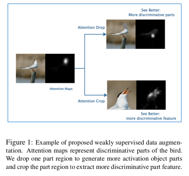
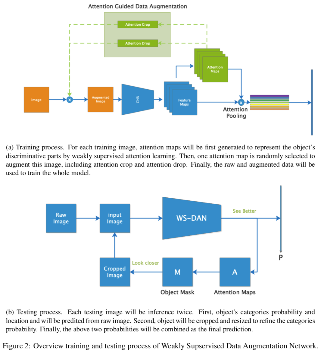
See Better Before Looking Closer: Weakly Supervised Data Augmentation Network for Fine-Grained Visual Classification
一篇来自中科院的 paper。充分利用每个样本的 attention map 在训练和测试阶段都作为有效信息送入模型来“学习”和“检验”模型,从而实现数据扩增(成对生成正反 label)和对非相关噪声特征更加鲁棒。
-
- Nov 2018
-
planetblender.com planetblender.com
Tags
Annotators
URL
- Aug 2018
-
oermap.org oermap.org
-
OER Impact Map
-
- Jul 2018
-
www.hacksparrow.com www.hacksparrow.com
- Apr 2018
-
geopandas.org geopandas.org
-
GeoPandas
Tags
Annotators
URL
-
-
python-visualization.github.io python-visualization.github.io
-
Folium
Tags
Annotators
URL
-
- Mar 2018
-
sites.udel.edu sites.udel.edu
-
Web Mapping
Test
-
- Jan 2018
-
stackoverflow.com stackoverflow.com
- Jun 2017
-
www.swamirara.com www.swamirara.com
- May 2017
-
enst31501sp2017.courses.bucknell.edu enst31501sp2017.courses.bucknell.edu
-
Arctic National Wildlife Refuge (ANWR)
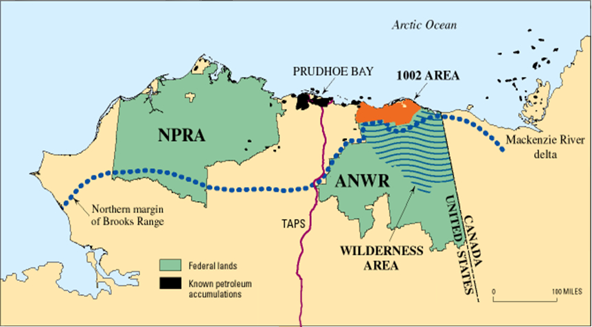
This map shows northern Alaska, the Arctic National Wildlife Refuge region, and the 1002 area which will be explained in a later section. The ANWR spans 19.2 million acres, and the 1002 area is 1.5 million acres.
"ANWR: Producing American Energy and Creating American Jobs." House Committee on Natural Resources. Accessed May 05, 2017. http://naturalresources.house.gov/anwr/.
-
- Apr 2017
-
wisc.pb.unizin.org wisc.pb.unizin.org
-
Edinburgh, Scotland
-
- Mar 2017
-
nfnh2017.scholar.bucknell.edu nfnh2017.scholar.bucknell.edu
-
Banks Island
Banks Island is the 5th largest western Arctic island in the Northwest Territories of Canada. The island was discovered by Lieutenant Frederick Beechey on Sir William Parry’s expedition in 1820. Parry named the island after Sir Joseph Banks, who was the president of the Royal Society in England. The island was first inhabited by Europeans in 1850 by the crew of Robert McClure after their ship, the Investigator got trapped. His men inhabited the island for two months before they were discovered and rescued. The island has been inhabited for different periods of time for roughly 3000 years by the Pre-Dorset, Thule, and Copper Inuit people, but now mainly houses trappers (Marsh 2010). Banks Island is well known for its wildlife, including Arctic foxes, wolves, caribou, polar bears, and a diverse bird population (Encyclopedia Britannica 2005). A bird sanctuary is located on Banks Island to protect bird breeding grounds from physical disturbances associated with thawing permafrost (Banks Island Migratory Bird Sanctuary n.d.). Banks Island is bordered by the Beaufort Sea, Amundsen Gulf, McClure Strait, and Prince of Wales Strait, as shown on the attached map. The topography of Banks Island varies between a northern and southern plateaus and low lands in between. Many glacier lakes can be found on Banks Island due to glacier erosion (Marsh 2010). Map: Description
Sources: “Banks Island.” Encyclopaedia Britannica. May 19, 2005. Accessed March 04, 2017. https://www.britannica.com/place/Banks-Island.
Marsh, James H. "Banks Island." The Canadian Encyclopedia. November 30, 2010. Accessed March 04, 2017. http://www.thecanadianencyclopedia.ca/en/article/banks-island/.
"Banks Island Migratory Bird Sanctuary (NT017)." Banks Island Migratory Bird Sanctuary (NT017). Accessed March 04, 2017. http://www.ibacanada.ca/mobile/site.jsp?siteID=NT017.
Tags
Annotators
URL
-
- Jan 2017
-
www.vox.com www.vox.com
-
which Nigerian states have implemented a form of sharia law (purple), which have implemented sharia law in some cases relating to family or personal law (yellow), and which use purely secular law (green).
map
-
- Sep 2016
-
allaboardhe.org allaboardhe.org
- Feb 2016
-
tachesdesens.blogspot.com tachesdesens.blogspot.com
-
A map without a story which engages
I read this line and questioned it. Then I thought about the Lord of the Rings and JRR Tolkien's map of Middle Earth.

Hailey, age 10, and I are reading the Warriors series by Erin Hunter. We're on the fifth of six books in this little epic fantasy of anthropomorphized cats forever at war for territory. My daughter and I have committed this map to memory generally but we still break from the narrative to study it when we can't quite picture where the latest cat drama is taking place. At bedtime and in our leisure time we worry, we predict, we rejoice and we study these fictional cats who are forever at war for territory.

-
-
impedagogy.com impedagogy.com
-
map
-
By the map, this map is a doozy to refold.
As all maps are .. once unfolded, they take on a story of their own ... https://www.youtube.com/watch?v=iYLPe9WLqe0
-
- Jan 2016
-
www.economist.com www.economist.com
- Oct 2015
-
cs231n.github.io cs231n.github.io
-
full loss function as coming from a Gaussian prior over the weight matrix WW, where instead of MLE we are performing the Maximum a posteriori (MAP) estimation. We mention these interpretations to help your intuitions, but the full details of this derivation are beyond the scope of this class.
Can anyone provide resources where I can find this derivation? In particular, the derivation for the regularization term \(R(W)\) coming from a Gaussian prior on \(W\).
Tags
Annotators
URL
-