https://web.archive.org/web/20260125104110/https://netzpolitik.org/2026/digitale-unterdrueckung-so-schalten-staaten-das-internet-aus/ Netzpolitik.org on internet blockades and mitigation tactics.
27 Matching Annotations
- Jan 2026
-
netzpolitik.org netzpolitik.org
-
gpswise.aero gpswise.aero
-
gps jamming and spoofing map
-
- Dec 2025
-
www.youtube.com www.youtube.com
-
we need to educate general practitioners, not just specialists, right? We need to to look at the anthroposine geoysiology and say, okay, we need some GPS for anthroposine geoysiology.
for - metaphor - medical - anthropocene - beyond experts, we need GPs for Anthropocene geophysiology - SRG comment - Is SRG GP for anthropocene?
-
-
-
We maken geen eigen AI-chips”, merkte Crijnen op, “maar omdat de hardware speciaal voor dit doel is gebouwd, kunnen we toekomstige in Europa gemaakte chips gemakkelijk integreren. Die flexibiliteit is cruciaal.”
This suggests they do use NVIDIA Jetson now, but don't need to if alternatives are available?
-
- Apr 2025
-
-
Coming to grips with the nature of asynchronicity can prove very demandingfor conference and forum participants.All new online learners and e-moderatorshave some problems with it during their training (or if you allow them to workuntrained directly with participants).'There is no quick and easy way around thisproblem. They really do need to experience it for themselves. For instance,participants ‘post’ contributions to one conference then immediately readmessages from others, or vice versa.A participant might read all his or her unreadmessages in several conferences and then post several responses and perhaps postsome topics to start a new theme. In any conference, this reading and postingof messages by a number of individuals can make the sequencing difficult tofollow.All the messages are available for any participant (or researcher) to view online,so the sequencing of messages, when viewed after an e-tivity is completed, looksrather more ordered than during the build-up. Yet trying to understand themafterwards is rather like following the moves of a chess or bridge game after itis over. When participants start using e-tivities, this apparent confusion causes awide range of responses. The twists of time and complexity can elicit quiteuncomfortable, confused reactions from participants and severe anxiety in a few.Although many people are now familiar with email, they are not used to thecomplexity of online conferences, bulletin boards or forums. I suggest that goodstructure, pacing and clear expectations of participants should be provided, notonly for the scaffolding process as a whole but for each e-tivity. In addition, thee-moderator, or his or her delegate, should summarize after 10 or 20 messages.
Esta parte do texto parece-me fundamental e relaciona-se com o anteriormente abordado, salvo erro, na primeira semana de aprendizagem deste curso. Relaciona-se diretamente com a necessidade crítica de ambientação dos estudantes aos ambientes digitais, salientando que a experiência prática da assincronia é fundamental para ultrapassar dificuldades iniciais. O excerto evidencia como a complexidade inerente às interações online pode causar confusão, desconforto ou mesmo ansiedade, especialmente em utilizadores pouco familiarizados com dinâmicas digitais síncronas e assíncronas.
Neste sentido, reforça-se a importância da emissão prévia de guias pedagógicos semanais (GPS) estruturantes (tal como indicado no artigo que nos foi oferecido a ler anteriormente), que orientem de forma explícita e detalhada os estudantes sobre como devem navegar e participar nestes contextos de ensino-aprendizagem. Estes guias devem indicar claramente quais são as expectativas relativamente à participação, ao ritmo de interação e ao tipo de contribuições esperadas, para que os estudantes se sintam seguros, orientados e capazes de gerir a sua aprendizagem de forma autónoma e eficaz no meio digital. A recomendação expressa no texto, para que o e-moderador realize periodicamente sínteses das mensagens (a cada 10 ou 20 intervenções), parece-me um exemplo prático e eficaz de orientação estruturante que facilita a compreensão e o acompanhamento dos conteúdos discutidos, mitigando dificuldades decorrentes da complexidade e da assincronia característica destes ambientes digitais. No entanto vou ao encontro daquilo que foi dito por um colega na sessão síncrona sobre populações de ensino muitos alargadas. Para o e-moderador - e a menos que possa utilizar atores de inteligência artificial para o ajudar neste contexto - será complexo gerir toda a informação gerada pela estudantes.
António Lista
-
- Dec 2022
-
www.gpsrchive.com www.gpsrchive.com
-
An absolute location can be confidently calculated only when four (or more) distance values are available.
-
- Sep 2022
-
-
G. Rizzi and M. L. Ruggiero, editors, Relativity in Rotating Frames, p. 167.Kluwer, Amsterdan, 2004,
- BOOK, LOOK FOR
-
J.-F. Pascual-S ́anchez, L. Flor ́ıa, A. San Miguel, and F. Vicente, editors, Reference Framesand Gravitomagnetism, p. 53. World Scientific, Singapore, 2001
- LOOK FOR
-
current GNSS: GPS and GLONASS. These systems are based on a Newtonian modelwhich is corrected numerically by important “relativistic effects”. This model uses the ECIand ECEF “Newtonian” reference frames, respectively for time reference and navigation
-
-
et us define location systems as the physical realizations of some coordinate systems.Location systems are of two different types: reference systems and positioning systems.The first ones are 4-dimensional reference systems which allow one observer, consideredat the origin, to assign four coordinates to the events of his neighborhood by means of atransmission of information. Due to the finite speed of light this assignment is intrinsicallyretarded with a time delay. The second one are 4-dimensional positioning systems (as usedin the SYPOR) which allow to every event of a given domain to know its proper coordinateswithout delay or in an immediate or instantaneous way.In Relativity, a (retarded) reference system can be constructed starting from an (immedi-ate) positioning system (it is sufficient that each event sends its coordinates to the observerat the origin) but not the other way around. In contrast, in Newtonian theory, 3-dimensionalreference and positioning systems are interchangeable and as the velocity of transmission ofinformation, the speed of light, is supposed to be infinite, the Newtonian reference systemsare not retarded but immediate.
- SEE
-
- Dec 2021
-
www.kron4.com www.kron4.com
- May 2021
-
fabiensanglard.net fabiensanglard.net
-
LocationManager can provide a GPS location (lat,long) every second. Meanwhile, TelephonyManager gives the cellID=(mmc,mcc,lac,cid) the radio is currently camping on. A cellID database[1], allows to know the (lat,long) of each CellID. What is left is to draw the itinerary (in red) and, for each second, a cellID-color-coded connection to the cell.
To design such a map, one needs to use these 2 Android components:
- LocationManager - provides a GPS location (
lat,long) every second - TelephonyManager - provides a cellID=(
mmc,mcc,lac,cid) the radio is currently camping on
and cellID database to know the (
lat,long) of each cell ID.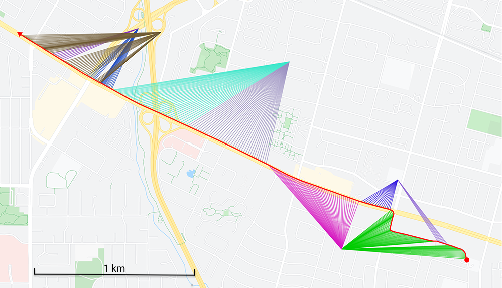
- LocationManager - provides a GPS location (
Tags
Annotators
URL
-
- Feb 2021
-
twitter.com twitter.com
-
Susan Cole-Haley on Twitter. (n.d.). Twitter. Retrieved 17 February 2021, from https://twitter.com/susancolehaley/status/1340231804431773699
-
-
www.abc.net.au www.abc.net.au
-
‘Why wouldn’t I get it?’: The experts leading the battle against COVID anti-vaxxers. (2021, February 7). https://www.abc.net.au/news/science/2021-02-08/covid-19-coronavirus-vaccine-misinformation-inoculation-theory/13125164
-
-
twitter.com twitter.com
-
ReconfigBehSci. (2021, February 8). UK faith leaders join to counter fears over vaccine in BAME communities https://t.co/OMVcWvIVhQ [Tweet]. @SciBeh. https://twitter.com/SciBeh/status/1358753137918623747
-
-
www.theguardian.com www.theguardian.com
-
UK faith leaders join to counter fears over vaccine in BAME communities. (2021, February 7). The Guardian. http://www.theguardian.com/society/2021/feb/07/faith-leaders-join-to-counter-fears-over-vaccine-among-bame-communities
-
- Aug 2020
-
www.newyorker.com www.newyorker.com
-
in June, 2017, a French oil tanker, the Atria, sailed across the Mediterranean, through the Bosporus strait, and into the Black Sea. As the ship approached the Russian city of Novorossiysk, the captain, Gurvan Le Meur, noticed that the ship’s navigation system appeared to have lost its G.P.S. signal. The signal soon returned, but the position it gave was way off. The Atria was apparently some forty kilometres inland, shipwrecked at the airport in Gelendzhik, a Russian resort town.
This could easily be used to spoof tanker vessels and hijack them electronically.
-
- Jun 2020
-
covid19.gleamproject.org covid19.gleamproject.org
-
Gleam Project | COVID-19 Mobility USA
-
-
psyarxiv.com psyarxiv.com
-
Bourassa, K. J. (2020, June 10). State-level Stay-at-home Orders and Objectively Measured Movement in the United States During the COVID-19 Pandemic. https://doi.org/10.31234/osf.io/hyd57
-
- May 2020
-
bfi.uchicago.edu bfi.uchicago.edu
-
Brzezinski, A., Kecht, V., Van Dijcke, D., Wright, A. (2020) Belief in Science Influences Physical Distancing in Response to COVID-19 Lockdown Policies. BFI. https://bfi.uchicago.edu/working-paper/belief-in-science-influences-physical-distancing-in-response-to-covid-19-lockdown-policies/
-
-
twitter.com twitter.com
-
David Garcia on Twitter
-
-
psyarxiv.com psyarxiv.com
-
Gollwitzer, A., Martel, C., Marshall, J., Höhs, J. M., & Bargh, J. A. (2020, May 5). Connecting Self-Reported Social Distancing to Real-World Behavior at the Individual and U.S. State Level. https://doi.org/10.31234/osf.io/kvnwp
-
- Apr 2020
-
arxiv.org arxiv.org
-
El Shoghri, A., et al. (2020 April 03). How mobility patterns drive disease spread: A case study using public transit passenger card travel data. 2019 IEEE 20th International Symposium on "A World of Wireless, Mobile and Multimedia Networks". DOI:10.1109/WoWMoM.2019.8793018
-
- Jun 2019
-
www.maptoaster.com www.maptoaster.com
-
How GPS Works
-
- Sep 2018
-
-
Best site to learn about fuel monitoring system and its uses
-
- Jan 2016
-
meiobit.com meiobit.com
-
Com a Wistiki, você nunca mais vai perder as chaves, carteira ou o seu cachorro
-
- Nov 2015
-
www.newyorker.com www.newyorker.com
-
If the space doctor’s ideas were wrong, your phone wouldn’t be able to tell where it was.
If all of the space boats travel at the same velocity and the same distance from the Earth's surface, the time shift of the on-board clock due to relativity would be the same. The difference between the clocks would be almost the same. How would the trouble appear?
-